
Research News


When Disaster Strikes, People Often Flee to Places That Feel Familiar
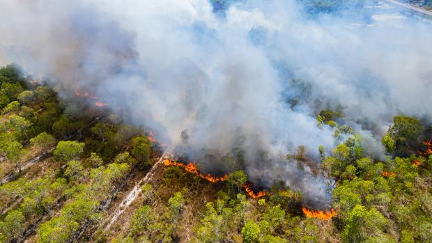
When the Marshall Fire tore through suburban Colorado in late 2021, residents had only hours to decide where to go. Some fled to nearby towns. Others stayed farther away for weeks or months. Now a recent study published in Humanities and Social Sciences Communications suggests those decisions were shaped not only by distance or danger, but also by something more human: the pull of familiar communities and social ties.
Researchers at NYU Tandon analyzed anonymized mobile phone location data from more than 200,000 devices in Colorado before and after the fast-moving wildfire, which destroyed more than 1,000 homes and displaced thousands of people. They combined those movement patterns with demographic data and measures of social connectedness between neighborhoods. Their conclusion: evacuees were more likely to choose destinations that resembled their home communities or where they had stronger social links.
“Even during a chaotic emergency, people do not move randomly,” says lead author Takahiro Yabe, Assistant Professor of Technology Management and Innovation and the Center for Urban Science + Progress. “They tend to seek places where they feel socially connected or where the community feels familiar.”
The study adds nuance to how scientists understand evacuation behavior. Traditional models often assume people head to the nearest available safe place or to larger population centers. But this research found that social factors strongly influenced where people actually went.
Most evacuees relocated between 20 and 60 kilometers from the fire zone, suggesting many wanted to remain relatively close to home. Yet when researchers compared real evacuation destinations with simulated destinations based only on population size and distance, the real destinations scored significantly higher for demographic similarity and friendship connections. In other words, people often chose places where they knew someone, or places that looked socially like where they came from.
The findings also revealed inequality in who could access those familiar refuges. Residents from whiter, wealthier, and more highly educated neighborhoods were more likely to evacuate to destinations with stronger social similarity and connectedness. Black, Asian, and lower-income populations were less likely to do so. That gap may matter because social networks can provide practical help during crises: a spare bedroom, child care, transportation, local knowledge, or emotional support.
“Access to social capital can shape recovery just as much as physical damage does,” says Vaidehi Raipat, a PhD candidate and lead author on the paper. “If some groups have fewer options to relocate into supportive communities, that can deepen existing inequalities after disasters.”
The team also examined what happened after the initial evacuation. People who relocated to areas with stronger social connectedness were more likely to return home over the following months. But those who moved to places that were demographically similar to their original communities were somewhat less likely to return, suggesting that a comfortable temporary destination may sometimes become a longer-term alternative.
That distinction could help officials plan for future climate disasters, which are becoming more frequent and more destructive. Wildfires, floods, and storms increasingly force sudden movement, yet emergency planning still tends to focus on roads, shelters, and hazard maps rather than the social geography of where people want to go.
The researchers argue that disaster response could improve by accounting for community ties. Knowing where evacuees are likely to head could help agencies position aid, anticipate population surges, and better support displaced residents. It could also identify people who lack strong networks and may need more assistance.
The study focused on one wildfire, so its authors caution that patterns may differ in hurricanes, floods, or other disasters. Still, the broader message is clear: in moments of upheaval, people often search not just for safety, but for belonging.

Could Physics Replace the Computer Keeping Your Robot Upright?
A new discovery in physics could help engineers stabilize robots and structures without relying on complex sensors and control systems, and design metamaterials and network systems that are presently beyond reach.
The finding, published in Nature Communications by researchers at NYU Tandon School of Engineering and Stony Brook University, shows that a mechanical system can be kept stable simply by switching between two behaviors at the right rhythm, even when neither behavior is stable on its own. No sensors watching the motion. No software constantly correcting it.
Once the timing is set, the physics does the rest.
Many machines must constantly stabilize their motion — keeping a walking robot from tipping over or preventing an aircraft wing from vibrating uncontrollably. Robots and other actively controlled systems typically do this by monitoring their environment and correcting their motion in real time, which requires sensors, processing power and software.
To test an alternative, the researchers built what they informally call the Frankenstein oscillator: a thin plastic strip fixed at one end with a small weight at the tip, subject to multiple loading conditions.
They then created two different kinds of instability. A magnetic coil pushed the beam away from its resting position in a way similar to a ball balanced on a horse’s saddle: if it moves slightly off center, it slides away in certain directions. A small fan blew air across the strip, feeding energy into the motion so that its swings grew larger rather than fading away, similar to how a playground swing rises higher when someone pushes at the right moment.
Both forces were switched on and off in carefully timed pulses.
The result was striking. Stability appeared only within a narrow band of switching speeds, with periods between roughly 218 and 238 milliseconds. Inside that window the beam stayed nearly still. Outside it, the motion quickly grew and the beam swung away.
Why should switching between two unstable behaviors make anything stable?
The idea builds on Kapitza's pendulum, named after Russian Nobel laureate Pyotr Kapitza. Vibrate the base of an inverted pendulum at exactly the right frequency and it stays upright, with no one watching or adjusting. Unlike a person balancing a stick on one hand, constantly shifting to stop it from falling, Kapitza's pendulum requires no such attention. Physics takes over.
In the classic case, the vibration provides a stabilizing effect, making the system virtually alternate between one stable and one unstable state. The new research asked a different question: what would happen if there were no stable states at all, if the physics were always pushing the system away from its resting position?
The answer depends on the type of instability involved. The “sliding” type — like the ball on the saddle — has one special direction in which motion actually shrinks instead of growing. The “swinging” type continually rotates the motion through different directions.
If the switching is timed correctly, that rotation can steer the motion into the shrinking direction before it has time to run away. The two instabilities, surprisingly, end up stabilizing each other.
“I have been thinking about the problem of stabilization of unstable systems through switching for over two decades,” said the paper’s senior author Maurizio Porfiri, an NYU Tandon Institute Professor and Director of both the NYU Urban Institute and the Center for Urban Science + Progress (CUSP). “In between ups and downs on the research, I was almost convinced that stabilization of two unstable systems would require some form of nonlinearity or even chaotic dynamics, but that is not the case: a simple, linear mechanical system can do the trick. The solution was in front of me for years, an extension of the marvelous ideas presented by Landau and Lifshitz in their Mechanics textbook that my uncle gave to me as a gift when I took my undergraduate dynamics class."
The researchers developed the theory first and then confirmed it experimentally with the beam. The narrow stability window they observed in the lab closely matched what the mathematical model predicted.
"Honestly, I had no belief that we would be able to demonstrate this phenomenon experimentally, as this involved working with a system that not only is unstable, but also features multiple sources of instability,” said Paolo Celli, Assistant Professor in Civil Engineering at Stony Brook University and co-corresponding author of the study. “The joy we felt when our carefully-designed experiment showed that narrow stability window is hard to explain. I am now super excited to see how this dynamic stabilization idea can be applied to other structural and robotic systems on the verge of instability"
The broader implication is a new design philosophy. Instead of always trying to eliminate instability, engineers may sometimes be able to build stable systems out of unstable pieces, harnessing the laws of physics rather than fighting them
The research was supported by the National Science Foundation through grants to both institutions. Along with Porfiri — who wrote about this research in a Behind the Paper post — and Celli, David Xiedeng — a Ph.D. student in Celli’s lab — is a co-author on the paper.

Watching a Film Reveals How the Brain Balances Eyes and Ears
For most of us, watching a movie feels effortless. We follow dialogue, read facial expressions, notice music cues and shifting scenery, and somehow fuse it all into a coherent story. But beneath that smooth experience, the brain is constantly deciding which sensory stream matters most in each moment.
A new study suggests that the frontal cortex, a region associated with planning and higher cognition, may act as a kind of traffic controller for this process — dynamically shifting attention between what we hear and what we see as a story unfolds.
To investigate, neuroscientists recorded brain activity directly from 19 epilepsy patients who had temporarily implanted electrodes for clinical monitoring. While in the hospital, participants watched a 12-minute multilingual short film* containing scenes in English, Greek, German, and French. Some foreign-language scenes included English subtitles, creating a natural test of how the brain handles changing audiovisual demands. Because the electrodes sat on or inside the brain, the researchers could track neural responses with millisecond precision, far faster than MRI scans allow.
They found that the frontal cortex was not processing all sensory information equally. Instead, it showed a striking internal division. Ventral, or lower, frontal regions responded more strongly to auditory information, while dorsal, or upper, frontal regions were more tuned to visual input.
“This suggests the frontal cortex has an organized map for handling different kinds of information during real-world experiences,” said first author Faxin Zhou, a Ph.D. candidate in the NYU Tandon Biomedical Engineering Department. “It is not just a general control center, it appears to separate sound and sight in a structured way.”
The pattern became even more interesting when the language changed. During English-language scenes, when listeners could understand speech directly, frontal brain areas leaned more heavily on auditory processing. But during scenes in unfamiliar languages, activity shifted toward visual regions, suggesting viewers relied more on facial expressions, gestures, and subtitles to follow the plot.
To confirm that interpretation, the team recruited online volunteers to rate short clips from the film. Participants judged which moments were most important to understanding the story and whether audio or visual cues were more useful in each scene. Those ratings closely matched the neural data: spoken English favored sound, while foreign-language scenes favored visual cues. In other words, the brain appears to reweight its sensory priorities on the fly.
“When comprehension through speech becomes harder, the brain flexibly reallocates resources toward visual signals,” said senior author Adeen Flinker, Associate Professor of Biomedical Engineering at NYU Tandon and Neurology at NYU Grossman School of Medicine. “That adaptability may be essential for navigating everyday environments filled with competing information.”
The findings help illuminate a long-standing question in neuroscience: how the brain merges multiple senses in realistic settings. Much prior research has relied on simplified laboratory tasks. Movies, by contrast, more closely resemble real life, where sensory cues arrive continuously and unpredictably.
The study also hints that the frontal cortex may do more than merge information after the fact. It may actively decide which stream — sound or sight — deserves priority before conscious understanding emerges.
That insight could have practical implications. Better understanding how the brain reallocates sensory attention may help researchers design therapies for people with language disorders, autism, attention deficits, or hearing loss. It could also inspire more adaptive artificial intelligence systems that shift between audio and visual inputs depending on context.
The work has limitations. Because the participants were hospital patients with epilepsy, they may not perfectly represent the general population. Electrode placement was determined by medical need, not experimental design, leaving some brain areas less sampled than others. Still, the precision of direct neural recording offers a rare glimpse into how the living human brain manages everyday perception.
*"Foreign Language," Adam Kelly Morton, Ack, No Ledge Creative
Zhou, F., Khalilian-Gourtani, A., Dugan, P. et al. Frontal cortex organization supporting audiovisual processing during naturalistic viewing. Nat Commun 17, 5355 (2026). https://doi.org/10.1038/s41467-026-73947-8
Seeing Through a Robot’s Eyes: Augmented Reality Helps Humans Predict Machine Behavior
As robots increasingly move out of factories and into workplaces, hospitals, warehouses and public spaces, a simple challenge becomes increasingly important: helping people understand what those machines are about to do.
A new study by researchers at Bowling Green State University (BGSU) and NYU Tandon suggests that augmented reality (AR) may offer a surprisingly effective solution. By overlaying a robot's goals, planned routes and safety zones onto the real world through a smartphone, the researchers found that people became significantly better at anticipating robot behavior and identifying potential hazards.
The work, published in the journal Empathic Computing, addresses a growing concern in human-robot interaction: transparency. While robots are becoming increasingly autonomous, their decision-making processes often remain opaque to nearby humans. That uncertainty can create confusion, reduce trust and, in some situations, compromise safety.
"One of the biggest challenges in human-robot collaboration is helping people understand what a robot intends to do before it acts," says co-author Vikram Kapila, Professor of Mechanical and Aerospace Engineering at NYU Tandon. "When users can see a robot's planned path, destination and safety boundaries, they are better able to anticipate its actions and make informed decisions about their own movements."
To tackle the problem, the researchers developed a smartphone-based AR application that communicates a mobile robot's intentions in real time. Using a standard Android phone equipped with Google's ARCore software, the system overlays digital information directly onto the user's view of the physical environment.
The application provides three types of visual information. One mode displays the robot's destination as a virtual location pushpin. Another reveals the route the robot plans to follow. A third shows a digital twin of the robot itself moving through the environment, complete with a visual buffer zone indicating areas where collisions or interference could occur.
Unlike many previous AR systems, which rely on specialized headsets or projection hardware, the new approach works on an ordinary smartphone. That simplicity could make the technology easier to deploy in workplaces where workers and autonomous machines routinely share space.
To test whether the system actually improved understanding, the researchers recruited 58 participants with varying levels of experience in robotics and augmented reality. Participants viewed a series of AR scenarios showing robot navigation tasks and then answered questions designed to measure what human-factors researchers call situational awareness — the ability to perceive, understand and predict events unfolding in an environment.
The evaluation was based on the Situational Awareness Global Assessment Technique, or SAGAT, a widely used framework that measures three levels of awareness: perception of relevant information, comprehension of its meaning and projection of future events.
Participants were asked to identify robot goals, recognize obstacles, determine whether objects would interfere with the robot's movement and predict which areas of the environment would remain safe for human occupancy.
The results were striking. Across all tasks, participants achieved an average situational-awareness score of 86.5 percent. They were particularly successful at recognizing obstacles and identifying safe zones where they could avoid interfering with the robot's operation.
Just as important, participants reported feeling more confident about working alongside robots. More than 96 percent said the AR interface improved their understanding of robot intentions and increased their confidence in predicting robot behavior.
"The findings demonstrate that even a lightweight, smartphone-based AR system can substantially improve people's awareness of a robot's goals and movements," Kapila says. "That increased understanding is an important foundation for building trust, safety and effective collaboration between humans and autonomous systems," said paper’s lead author Sonia Chacko, Assistant Professor at BGSU, who received her doctoral degree from NYU Tandon.
The study arrives at a moment when robots are becoming more common in settings that were once the exclusive domain of humans. Warehouses increasingly rely on autonomous mobile robots to move goods. Hospitals are experimenting with robotic delivery systems. Service robots are beginning to appear in airports, hotels and retail environments. In such settings, the ability to quickly understand what a robot is planning to do may be as important as the robot's ability to understand human behavior.
Kapila also recently developed a mixed-reality system that allows people to communicate force instructions to a robot using a tablet. Instead of programming the robot through complex controls, users place a virtual arrow on the tablet screen over a real-world object. The arrow's position tells the robot where to apply force, its orientation indicates the direction of the force, and its length specifies how much force should be used. The robot then carries out the task and provides visual feedback through a moving virtual indicator that shows whether the desired force has been achieved.
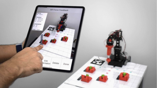
The findings reported in the journal Machines, authored by Christian Lourido, Kishan Reddy Raghunath and Kapila, suggest that mixed reality can make human-robot collaboration more intuitive by allowing people to communicate complex physical intentions visually rather than through specialized programming or expensive haptic equipment. Such technology could eventually be useful in manufacturing, healthcare, and other environments where humans and robots must work together safely and precisely.
The findings suggest that making robotic intentions visible may help bridge one of the most persistent gaps in human-machine collaboration. As autonomous systems become more common in everyday life, a digital window into a robot's plans could make working alongside them feel far more comfortable.
Chacko S, Kapila V. Making robots understandable: Augmented reality for enhancing situational awareness in human–robot co-located environments. Empath Comput. 2026;2:202517. https://doi.org/10.70401/ec.2026.0016
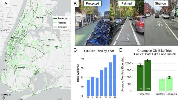
Protected Bike Lanes Causally Increase NYC Bikeshare Ridership, But Benefits Are Not Distributed Equally
Protected bike lanes increase Citi Bike ridership in New York City, but painted bike lanes and sharrows do not show a statistically significant causal effect on ridership after accounting for confounding factors, according to a new study from researchers at NYU's Tandon School of Engineering published this week in npj Sustainable Mobility and Transport.
The findings address a longstanding question in transportation planning: if and to what extent do different types of bicycle infrastructure actually encourage more people to ride.
Protected bike lanes physically separate cyclists from vehicle traffic using barriers such as curbs, parked cars, or flexible posts. Painted bike lanes provide only a painted stripe between cyclists and cars, while sharrows are bicycle symbols painted onto shared traffic lanes.
Using approximately 72 million Citi Bike trips recorded between 2013 and 2024 (a period of significant ridership growth), the researchers linked trip data to bicycle infrastructure located near stations across New York City.
Initial results suggested that both protected and painted facilities were associated with increased ridership. Stations near newly-installed protected bike lanes saw an average increase in trips of 18%, while stations near painted bike lanes and sharrows experienced an average increase of about 14%.
However, those initial before-and-after comparisons do not account for the fact that bike lanes are often installed in areas where cycling activity is already increasing.To isolate the effects of the infrastructure itself, the researchers used propensity score matching and difference-in-differences analysis, statistical methods designed to compare similar locations while controlling for pre-existing neighborhood characteristics and ridership trends.
After applying those methods, only protected bike lanes showed a statistically significant causal effect on Citi Bike ridership. The researchers estimated an average increase of approximately 379 additional rides per station per month following installation of protected lanes. In contrast, painted bike lanes and sharrows did not show a statistically significant causal effect on ridership.
"Not all bike lanes are created equal," said Takahiro Yabe, Assistant Professor in the Department of Technology Management and Innovation (TMI) and the Center for Urban Science + Progress (CUSP) at NYU Tandon School of Engineering. "When cities invest in cycling infrastructure, the design details can determine whether a lane simply exists on a map or actually changes how people travel. That matters for transportation, public health, and sustainability, especially when cities are making difficult choices about how to invest limited resources."
"Painted bike lanes and sharrows may cost less and face less political pushback, but we now have evidence at a massive scale that protected bike lanes are really what can move the needle on ridership," said Marcel Moran, the lead author of the paper. Moran is currently an Assistant Professor at San José State University, and was a Faculty Fellow at CUSP during this project.
The study also examined whether the effects of protected bike lanes differed across neighborhoods. The researchers found that the positive ridership effect was statistically significant only in Census block groups with the lowest share of Black residents. In neighborhoods with higher shares of Black residents, they did not detect a statistically significant causal effect on Citi Bike ridership.
"Protected bike lanes seem to work best where cycling was already a realistic option for people,” said Malik Salman, a paper co-author. Salman is an NYU CUSP alumni and currently a CUSP Research Scholar in Yabe’s lab. “In communities where residents face other barriers — cost, discriminatory policing, a history of being left out of the planning process — the infrastructure alone may not be enough to change behavior. That's not an argument against building protected lanes. It's an argument for doing more alongside them."
The results were more encouraging for older adults. In Census block groups with the highest share of residents between ages 60 and 79, protected bike lanes produced particularly strong ridership gains. The researchers suggest that older adults may be especially responsive to infrastructure that reduces perceived traffic-safety risks. This aligns with evidence from cities like Copenhagen, which feature an expansive network of protected bike lanes, as well as high ridership among older adults.
The study comes as New York City's bicycle network has expanded from roughly 900 miles of bike lanes in 2014 to approximately 1,500 miles by 2024, while Citi Bike recorded a system-high of roughly 45 million trips in 2024. The authors say their methodology could be applied to other cities with publicly available bikeshare and bike-lane data, including Chicago, Boston, San Francisco, and Washington, D.C.
Moran, M., Salman, M. & Yabe, T. Heterogeneous impacts of protected bike lanes on bikeshare behavior across demographic groups in New York. npj. Sustain. Mobil. Transp. 3, 39 (2026). https://doi.org/10.1038/s44333-026-00107-2

A 3-D Printed Stent, Shaped Like a Lily, Could Speed Recovery After Weight-Loss Surgery
Each year, about 250,000 Americans undergo sleeve gastrectomy, one of the most common weight-loss operations in the United States. For most patients, recovery is uneventful.
But for a small share — between one and three percent in routine cases, and as many as one in ten in revision surgeries — the procedure can leave behind a gastric leak, in which fluid escapes from the stomach and forms an abscess.
Treating those leaks can be a long process. Doctors usually rely on endoscopic internal drainage, threading a small plastic tube called a double-pigtail stent through the stomach wall so the fluid can drain. But the devices typically used are built for bile ducts, not for the oddly shaped cavities created by gastric leaks.
That mismatch matters. The stents can slip, drain slowly and require repeated procedures before the leak resolves.
Now, researchers at New York University say they have found a better approach by changing the shape of the stent itself. Their findings have been published in Advanced Healthcare Materials.
Their prototype, called the Lily stent, is the first product of a design framework the researchers named PETALS, for Personalized Endoscopic Transmural Abscess Leak Solution, a mathematical approach to optimizing drain shape for complex biological fluids that the team says could be applied beyond gastric leaks to other drainage challenges in the body.
Using computer simulations and mathematical modeling, the researchers found that length and inner diameter mattered most, while the curled anchoring ends had little effect on fluid flow. Counterintuitively, a wider tube does not drain better. Increasing the inner diameter shrinks the gap around the outside of the stent, where most of the fluid actually travels. That means exterior topography, not interior volume, is the primary driver of drainage performance.
That insight is the foundation of the PETALS framework. By mathematically optimizing the outer surface geometry for the viscosity and pressure of gastric fluid, the team arrived at their new stent, a six-part structure that creates more effective routes for fluid to move around the device.
“The key insight is that the geometry of the tube’s cross-section, especially the exterior surface, fundamentally determines how fast fluid moves through and around it,” said Khalil Ramadi, an assistant professor at NYU Abu Dhabi and NYU Tandon School of Engineering and the study’s senior author. “We’re not just making it out of a different material. We’re changing the shape to make it work better.”
If the results hold up beyond the lab, the payoff could be meaningful. Roughly 2,500 people in the United States require treatment each year for gastric leaks after bariatric surgery. Faster drainage could shorten recovery and reduce the need for repeat procedures, easing both the burden on patients and the cost of care.
The device is still early in development. So far it has been tested only in simulations and benchtop models. Animal studies will be needed before it can move closer to clinical use.
The Lily stent also proved more flexible than the commercial polyethylene device it is meant to replace, an attribute surgeons associate with better patient tolerance and reduced tissue damage. In short-term animal studies, tissue surrounding the implanted material showed no significant difference from tissue around standard polyethylene, an early indicator of biocompatibility.
The researchers note that the Lily design's constant cross-section geometry would allow it to be manufactured by conventional extrusion methods, without requiring hospitals to invest in 3-D printing infrastructure.
"Our work shifts the focus from just placing a stent to engineering its function at a structural level," said Parima Phowarasoontorn, a research assistant in Ramadi’s NYU Abu Dhabi lab and the paper’s first author. "Instead of simple tubes, we introduce cross-sectional designs that improve drainage while remaining compatible with existing endoscopic delivery procedures."
The Lily stent research follows Ramadi's lab's announcement of the CORAL capsule, an ingestible pill whose coral-like structure traps bacteria from the small intestine, enabling researchers to study microbial communities that contribute to certain diseases. Both devices draw on nature's own geometry to solve medical problems that conventional tools have struggled to address.
Phowarasoontorn P, Ko Y, Barajas-Gamboa JS, Pantoja JP, Al-Ketan O, Ali M, Sohn S, Naser HT, Dabbour AH, Khlaifat B, AlZubaidi A, Vega CA, Rodriguez J, Kroh M, Ramadi KB. Enhanced Endoscopic Internal Drainage of Gastric Abscess Through Additively Manufactured Stents. Adv Healthc Mater. 2026 Apr 2:e05860. doi: 10.1002/adhm.202505860.
New Research Suggests Consistency, Not Complexity, Is the Key to Teaching Robots Dexterity
Teaching robots to manipulate objects with humanlike dexterity has long been one of robotics’ toughest challenges. Tasks such as rotating an object in-hand or coordinating two robot arms to maneuver a bulky item require constant changes in contact, grip and motion, skills that are difficult both to program and to demonstrate through human teleoperation.
Now researchers from NYU Tandon and the Robotics and AI Institute have shown that robots may be able to learn these behaviors from planning algorithms instead of human demonstrations. Their study, published in IEEE Robotics and Automation Letters (RA-L), suggests that the quality of synthetic training data matters more than researchers previously realized. The paper was recently awarded the IEEE RA-L Best Paper Award.
Modern robot-learning systems often rely on imitation learning, in which robots copy demonstrations collected from humans controlling robotic hardware remotely. But teleoperation systems are poorly suited for highly dexterous tasks involving many simultaneous contact points and finger movements. To bypass that limitation, the researchers used motion-planning algorithms to automatically generate demonstrations inside physics simulations. The idea was to let robots learn from virtual experience rather than from people. But the team discovered a problem: popular planning systems known as rapidly exploring random trees, or RRTs, produce demonstrations that are too inconsistent.
“These planners are very good at finding solutions,” says lead author Huaijiang Zhu. “But when every solution looks different, the learning system struggles to figure out what behavior it should imitate.”
The team found that the planners’ randomness created what researchers call “high-entropy” data — demonstrations that solved the same task through wildly different motions. Although this diversity helps planners explore possible solutions, it makes imitation learning less effective.
To address the issue, the researchers developed alternative planning approaches that generated more consistent demonstrations. One method emphasized steady progress toward a goal rather than random exploration, while another reused a library of predefined motions to reduce variability.
The researchers tested the approach on two difficult manipulation problems. In one task, two robot arms had to rotate a large cylinder by 180 degrees while repeatedly changing their grips. In another, a dexterous robotic hand manipulated a cube in its palm to match target orientations. They found that robots trained on the more consistent demonstrations achieved much higher success rates than those trained on standard RRT-generated data, even when using relatively small datasets. In the dual-arm task, the improved system reached near-perfect performance with only 100 demonstrations.
The team also transferred the learned policies directly from simulation to real-world hardware without additional retraining. The dual-arm robot succeeded in 90 percent of physical trials, while the dexterous hand completed about 62 percent of its attempts.
The study highlights a growing shift in robotics research. Rather than treating classical motion planning and machine learning as separate approaches, scientists are increasingly combining them. In this case, planning algorithms effectively served as teachers for neural-network-based robot policies.
The findings also reinforce a broader lesson emerging across AI: more data is not always better. Carefully structured, consistent examples may teach machines more effectively than large quantities of noisy or highly variable demonstrations.
Challenges remain, particularly for tasks involving deformable objects or soft robotic hands that are difficult to simulate accurately. But the work suggests a future in which robots learn increasingly sophisticated physical skills from virtual environments designed not just to produce solutions, but to produce solutions machines can understand.
H. Zhu et al., "Should We Learn Contact-Rich Manipulation Policies From Sampling-Based Planners?," in IEEE Robotics and Automation Letters, vol. 10, no. 6, pp. 6248-6255, June 2025, doi: 10.1109/LRA.2025.3564701.
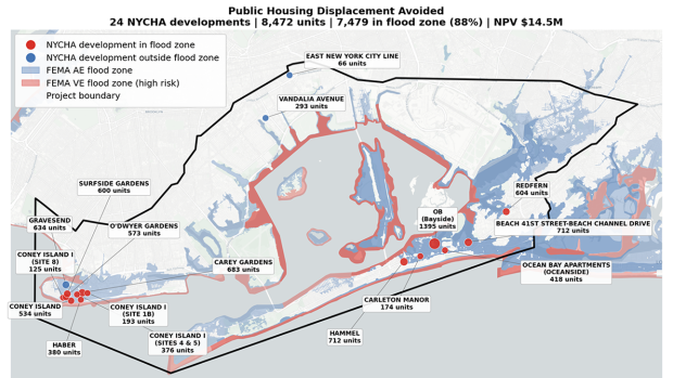
NYU Tandon and NEC Put a Price Tag on Flood Protection in the Rockaways
In the Rockaways, a peninsula neighborhood in Queens, New York City, decisions about where to invest in flood barriers, beach nourishment, or shoreline reinforcement could soon be backed by something that has long been missing from the conversation. A clear accounting of what those investments are actually worth.
A research project from NYU Tandon School of Engineering's Center for Urban Science and Progress (CUSP), developed in partnership with NEC Corporation, used geospatial analysis and economic modeling to do exactly that.
But the more disruptive question the project raises is not just what flood resilience is worth, but who is receiving that value, and why they are not yet part of the funding conversation.
Developed through CUSP's Capstone Program, a two-semester initiative in which students work with external partners to address real-world urban challenges, the project was presented on May 1 at the Urban Data Science Showcase at NYU Tandon’s Brooklyn campus.
NEC and NYU have subsequently signed a Memorandum of Understanding (MOU) committing both organizations to further studies in urban disaster prevention, resilience, and advanced technology.
At the core of the project is a value chain framework that maps how a single flood protection investment generates ripple effects across transportation, housing, public health, and community wellbeing. Rather than treating these benefits as abstract, the team built five quantitative models that convert avoided damages into dollar figures.
"The central insight here is that flood resilience creates enormous economic value for stakeholders who have never been asked to contribute to its cost — transit operators, insurers, healthcare systems, tourism economies,” said the project’s Faculty Mentor Yuki Miura, assistant professor at CUSP and Tandon’s Department of Mechanical and Aerospace Engineering, and a member of the New York City Panel on Climate Change. “These are not passive bystanders to flood risk. They are material beneficiaries. Quantifying that stake is the first step to bringing them into the investment conversation."
The numbers are striking. Avoiding traffic disruption from roadway flooding amounts to an estimated $105 million over ten years. Mental health costs linked to flood-triggered trauma, drawing on post-Sandy PTSD rates three times the national average among Rockaway Peninsula residents, reach $501 million per major flood event.
Emergency shelter costs for the 15,932 public housing residents living in the flood zone approach $16.5 million per event. Protecting beachfront tourism preserves an estimated $170 million in revenue over a decade. A fifth model accounts for the health burden that construction noise places on the roughly 44,000 residents living near active worksites.
Taken together, the analysis suggests losses of up to approximately $800 million could potentially be avoided through flood protection measures currently underway under the Greater Rockaway Resilience Plan.
The models were built using ArcGIS and Excel, integrating spatial flood hazard data with socioeconomic indicators, including land use, tax records, and demographics. Findings were validated through prior research comparisons and direct interviews with Rockaway residents, community organizations, and representatives from the public and private sectors.
"When we can show a health system that a flood barrier reduces its emergency admissions by a measurable margin, or show a transit authority the precise cost of service disruption it avoids, the question of who should fund resilience infrastructure starts to have a different answer," said Miura. "That is not only a Rockaways question. It is a question every city with a coastline is facing."
For NEC, whose expertise lies in value chain modeling and digital technologies, the project reflects a broader strategic priority.
"While strengthening resilience is urgent, public and private sector efforts often remain fragmented, and for individual projects, ROI is often unclear," said Ryutaro Adachi, Executive Professional at NEC's GX Business Development Division. "This research presents a basic framework for evaluating the economic impact of projects with ambiguous effects and suggests the potential for expanding future funding methods."
Eighty-eight percent of public housing units on the peninsula sit within the flood zone, and waitlists stretch beyond five years, meaning displaced residents have almost nowhere to go when flooding strikes.
While the Rockaways served as the test case, the framework is designed to generalize across geographies and infrastructure contexts. Under the MOU, NEC and NYU Tandon will explore opportunities for social implementation of the findings, including engagement with financial institutions on new financing methods made possible by technologies such as satellite image analysis, AI, and remote sensing.
The project was led by CUSP graduate students Christian Humann, Kamili Afra, and Ziming Xiong, with Miura as faculty mentor and Adachi and Takuo Shioda of NEC Corporation as project sponsors.

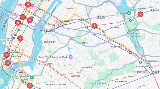
Downtown Brooklyn as a Living Lab for AI-Driven Retail Planning
In Downtown Brooklyn, decisions about where to open a coffee shop, attract a retailer, or fill a vacant storefront could soon be informed by an unlikely source: artificial intelligence trained on how people actually move through the neighborhood.
A new research project from the Resilient Urban Networks Lab, led by Takahiro Yabe — an assistant professor at the Center for Urban Science and Progress (CUSP) and the Department of Technology Management and Innovation at NYU Tandon School of Engineering — is using anonymized mobility data and advanced AI models to better understand how people choose where to spend time and how those choices shape the local economy.
Developed in collaboration with the Downtown Brooklyn Partnership (DBP), the work aims to provide a practical tool for retail planning and economic development.
At the core of the project is a system that models thousands of individuals as “AI agents,” each representing a type of person who lives, works, or visits Downtown Brooklyn. Using mobile phone location data, demographic information, and business attributes, researchers created a “synthetic population” of roughly 20,000 agents that simulate real-world behavior.
“We’re essentially building something like SimCity, but grounded in real human behavior,” said Yabe.
These agents can be used to test “what-if” scenarios, such as how foot traffic might change if a new retailer opens, a grocery store is introduced, or a popular café closes. Earlier research could estimate the economic spillover effects of business closures, but this approach goes further by simulating how entirely new additions, such as parks, retail stores, or entertainment venues, might reshape activity across the neighborhood.
“For retail operators, real estate developers, and property owners, one of the biggest challenges is uncertainty,” said Yabe. “This framework allows us to test scenarios before making costly decisions, whether that’s introducing a new tenant, redesigning a space, or rethinking an entire retail mix. The goal is to turn data into a practical decision-making tool that reduces risk and improves outcomes for neighborhoods.”
For organizations like the DBP, which helped shape the research questions and provided local context, the goal is not just to understand behavior but to support decisions about retail strategy. This includes identifying what types of businesses should fill vacant storefronts to attract visitors and encourage them to stay longer in the area.
“They help us frame the right questions,” Yabe said, noting that the Partnership has been closely involved in identifying real-world use cases and providing information about local business openings, closures, and potential tenants.
"Understanding where people go and why is the foundation of a healthy retail market," said Mark Landolina, Senior Director of Real Estate and Economic Development at DBP. "This research gives us the ability to simulate how foot traffic and consumer demand shift when a new business opens or closes before it happens. That means we can go to landlords and tenants with concrete, data-backed recommendations about what types of businesses belong where, taking the guesswork out of leasing decisions and helping the market respond to real demand. That's how you fill the right storefronts with the right businesses and build a stronger Downtown Brooklyn."
Early findings highlight how interconnected the neighborhood’s economy is. In one simulation, when a popular coffee shop was removed, customer demand did not shift to a single competitor. Instead, it spread across many nearby businesses, with most alternatives located within a short walking distance.
This pattern suggests that Downtown Brooklyn operates as a tightly linked retail ecosystem, where businesses share and redistribute foot traffic rather than compete in isolation. It also points to the importance of proximity and diversity in sustaining neighborhood vitality.
The research also demonstrates that everyday movement patterns, particularly predictable routines like weekday lunch trips, can be modeled with a high degree of accuracy. The model has been tested against real-world business openings and closures, and researchers say the level of predictive accuracy improves significantly when combining behavioral personas with spatial and business data.
“The level of accuracy we’re seeing is really, really high, especially for out-of-sample predictions compared to traditional machine learning approaches,” Yabe said.
While the current analysis focuses on restaurant visits as a starting point, the broader framework can be applied to a wide range of retail and urban planning questions, from tenant mix to long-term neighborhood development.
The project is part of NYU CUSP’s capstone program, a two-semester initiative in which students work with external partners to address real-world urban challenges. It was presented on May 1 at the Urban Data Science Showcase at NYU’s Brooklyn campus. The project, titled Enhancing Downtown Brooklyn’s Retail Market Through Data-Driven Interventions, was led by CUSP graduate students Sizhe (Alex) Xu and Divya Natekar, with Ph.D. students DongHak Lee and Boyang Li (CUSP, TMI) as student mentors, Yabe as the faculty mentor, and the DBP serving as the project sponsor.
About DBP Living Lab:
Downtown Brooklyn is a place where collaboration and innovation come together to solve real problems. Through our Living Lab program, DBP partners with groups to solve quality of life challenges facing cities, using Downtown Brooklyn as a platform to test technologies and generate real-world insights. This initiative is a perfect example of what the Living Lab is all about, bringing NYU Tandon's cutting-edge research and technology to work right in our own backyard.

Why Faster AI Isn’t Always Better
In the race to make AI models not just reason better but respond faster, latency — the delay before an answer appears — is often treated as a purely technical constraint, something to minimize and move past. But how is this relentless push for speed actually impacting the people using these systems every day?
There is a rich body of work in human-computer interaction linking faster response times to better usability. But AI models are fundamentally different from the deterministic systems that previous research was built on. When you wait for a file to download or a page to load, the outcome is fixed and predictable. AI models are probabilistic — you cannot anticipate the precise response. Their conversational interface means users naturally read human social cues into the interaction. A pause might be read as the AI "thinking," for instance. Users are increasingly asked to choose between faster models and slower, deeper-reasoning ones, without guidance on what that choice actually means for their experience.
A recent study presented at CHI’26 explored how response timing shapes the way people use and evaluate AI systems. Felicia Fang-Yi Tan and Technology Management and Innovation Professor Oded Nov recruited 240 participants and asked them to complete common knowledge work tasks using a chatbot. Some tasks focused on creation, such as brainstorming ideas or drafting text. Others centered on advice, like evaluating decisions or offering recommendations. Crucially, the system was engineered to respond at different speeds. Some participants received answers after just two seconds, while others waited nine or even twenty seconds.
The results challenge a long standing assumption in human-computer interaction that faster is always better.
“People assume faster AI is better, but our findings show that timing actually shapes how intelligence is perceived,” says Tan. “A short pause can signal care and deliberation, making the same response feel more thoughtful and useful, even when nothing about the underlying AI model has changed.”
Surprisingly, how quickly the AI responded did not significantly change how people behaved (e.g., frequency of prompting, copy-pasting). Participants prompted just as much and interacted with the system in broadly similar ways regardless of whether they waited two seconds or twenty. Instead, behavior depended more on the type of task. Participants attempting creation tasks (which involve producing new content such as writing) prompted more back and forth, with users refining and iterating on ideas. Advice tasks (which involve providing guidance, critique, or evaluation) led to fewer, more focused exchanges.
Where timing did matter was in perception. Participants who received two-second responses consistently rated the AI’s answers as less thoughtful and less useful. In contrast, those who experienced longer delays tended to view the same kinds of responses more favorably. Many interpreted the pause as a sign that the system was “thinking,” attributing greater care and deliberation to its output.
This effect highlights a subtle but powerful feature of human psychology. In everyday conversation, pauses carry meaning. A quick reply can feel impulsive, while a measured delay suggests reflection. People appear to apply these same social expectations to machines, even when they know they are interacting with software.
The implications extend beyond user experience. Given that latency is an inherent feature of today's AI models, perhaps the more productive question is not how to eliminate it, but what it can be designed to do. Positive friction refers to intentional slowdowns designed to promote cognitive benefits such as reflection. Rather than treating every millisecond of waiting as waste, designers might ask: what can this pause do?
The study also surfaces important ethical considerations. If people equate longer response times with higher quality, they may place undue trust in slower systems, regardless of whether the output is actually better. This raises ethical questions about whether AI systems should be designed to manage timing in ways that shape user perception. And if so, whether users should be informed when they are.