NYU Tandon Supports MTA in Combating Climate Threats
Research team developed computer model that quickly tests hundreds of resilience strategies to determine the best ways to defend subways against coastal storm surge flooding
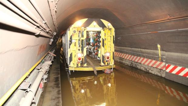
New York City Transit employees are pumping water out of the Cranberry Street Tunnel, which carries the A and C trains between Brooklyn and Manhattan underneath the East River. Photo credit: MTA New York City Transit / Leonard Wiggins
As transit agencies face growing climate risks and limited capital budgets, deciding which flood protection measures to implement — and where — has become a critical challenge.
Now, a research team at NYU Tandon School of Engineering has built a computer modeling framework that allows agencies to rapidly test and prioritize hundreds of subway resilience strategies for coastal storm surge flooding before committing to major infrastructure investments.
Developed in collaboration with researchers at Columbia University and Princeton University, the model enables the New York Metropolitan Transportation Authority (MTA) to simulate coastal storm surge flooding scenarios under different climate projections and evaluate which combinations of coastal barriers and station-level protections will provide the greatest return on investment.
The physics-based approach, published in Transportation Research, calculates flooding extent and economic losses for each scenario in about one minute on a standard laptop. This speed makes comprehensive resilience planning practical for the MTA, the state agency that oversees NYC's public transportation system.
The research team validated its simulation by accurately reproducing Superstorm Sandy's 2012 flooding patterns. That storm inundated 150 subway stations across New York City, causing $5 billion in repair costs to stations, tunnels, and electrical systems, plus additional economic losses from extended service disruptions.
Since that event, the MTA has invested $7.6 billion in repairs and nearly 4,000 coastal surge protections, including elevating critical infrastructure, securing entrances at underground subway stations, and installing marine doors at the Hugh L. Carey and Queens Midtown tunnels.
“Protecting our infrastructure and the New Yorkers that rely on it from the impacts of climate change is one of the MTA's top priorities," said Eric Wilson, Senior Vice President of Climate & Land Use at the MTA. "Innovative tools like this give us a powerful, data-driven way to evaluate resilience investments before we build them, helping ensure every dollar we spend strengthens the system and safeguards service for millions of daily riders."
"As extreme storms become more frequent and sea level rises, transit agencies need reliable tools to determine how protective measures will actually perform in these changing circumstances before committing billions in infrastructure investments," said Yuki Miura, the study's lead author and assistant professor at NYU Tandon, where she is a faculty member in the newly established NYU Urban Institute. “Our model lets agencies rapidly compare hundreds of strategies under different future conditions. That makes it possible to identify solutions that are not only cost-effective, but also robust to uncertainty.”
Working with MTA and NYC government officials, the research team leveraged the model's speed to rapidly test numerous flooding scenarios for Lower Manhattan's subway system (below 34th Street). The study presents 13 representative stress tests through the end of the century, each combining Superstorm Sandy-level storm surges with projected sea level rise and various protective strategies.
The modeling shows that layered strategies — combining coastal barriers with targeted protection at key subway openings — can substantially reduce flood risk in a cost-effective and system-wide manner. Raising Lower Manhattan's entire coastline by two meters (about 6.5 feet) could prevent subway flooding even with mid-century sea level rise.
A hybrid approach — completing the East Side Coastal Resiliency seawall paired with sealing the 1,500 most critical of the subway's 3,500 openings (entrances, vents, stairways, and other entry points) — would cost about the same as sealing all 3,500 openings, but could also protect neighborhood streets, buildings, and infrastructure from coastal flooding, not only the subway itself. For the MTA, its 4,000 coastal surge protections are a critical first line of defense, and the East Side Coastal Resiliency seawall is a secondary protection.
The analysis reveals a counterintuitive finding: flood risk does not scale linearly. Instead, localized vulnerabilities at critical junctions can trigger cascading failures throughout the system, meaning strategic investments at a handful of key locations can be far more effective than broadly distributed protections.
In addition to calculating flood depths both above and below ground, the study quantifies economic impacts from subway inoperability. The researchers estimate a Superstorm Sandy-level storm today would cause $5.5 billion in economic losses to Manhattan from transit disruptions alone — separate from repair costs — given that 40-60% of New Yorkers depend on public transportation for daily commutes. This estimate does not account for the coastal surge protections that the MTA has implemented. These protections would be deployed by the MTA during a Superstorm Sandy-level storm, reducing the associated economic loss due to transit disruptions.
The research team developed the model in coordination with the New York City Transit Authority, a division of the MTA, which provided detailed system specifications, including tunnel dimensions, station volumes, and opening locations, while maintaining security considerations.
"We're grateful for the productive collaboration with the MTA," said Miura, who has faculty appointments in both Tandon's Center for Urban Science + Progress and its Mechanical and Aerospace Engineering Department. "Their engagement has been essential in developing a tool that supports evidence-based decision-making for infrastructure investments."
Miura points out that ongoing work is exploring how this framework can be integrated into long-term capital planning and adapted for other infrastructure systems facing climate risk. While this study focused on New York City, the methodology can be adapted to other coastal cities with underground transit infrastructure.
The research was supported by the National Science Foundation. The study's senior author is George Deodatis of Columbia University. Co-authors are Christine Y. Blackshaw of Princeton University, Michelle S. Zhang of Columbia University, and Kyle T. Mandli of the Flatiron Institute.
Yuki Miura, Christine Y. Blackshaw, Michelle S. Zhang, Kyle T. Mandli, George Deodatis,
Coastal storm-induced flooding risk of the New York City subway amid climate change,
Transportation Research Part D: Transport and Environment, Volume 149,2025, 104974, ISSN 1361-9209, https://doi.org/10.1016/j.trd.2025.104974.