Omar Wani is an assistant professor in the Department of Civil, Urban and Environmental Engineering at New York University, where he leads the Wani Research Group. The group combines statistical and computational methods to study the dynamics of hydroclimatic risk in various built and natural environments, which are often interconnected and coupled systems.
Before joining NYU, Dr. Wani conducted his postdoctoral work at the University of California Berkeley's Environmental Systems Dynamics Lab and the California Institute of Technology’s Division of Geological and Planetary Sciences. He has a Ph.D. in Environmental Engineering from ETH Zurich, Switzerland, a joint master's degree from the Delft Institute for Water Education, the Netherlands and the Technical University of Dresden, Germany, and a bachelor’s degree in Civil Engineering from the Indian Institute of Technology Roorkee, India.
Research News
When the Rain Comes, Some New York City Subway Riders Stay Home. Scientists Are Now Mapping Exactly Who, and Where
On a sweltering August afternoon or in the teeth of a winter storm, New York City subway riders make a quiet calculation: Is the trip worth it?
A new study published in npj Sustainable Mobility and Transport takes a detailed look at how those decisions show up in ridership patterns across the system, and how they vary from station to station.
Researchers from NYU Tandon, the University of Louisville, and the University of Hong Kong analyzed hourly ridership at 10 major subway stations between 2023 and 2025. Using a statistical technique called vine copula modeling, they examined how stations’ ridership moves together under different weather conditions rather than treating each station as an isolated case.
“Think about what actually happens when a storm hits,” said Joseph Chow, one of the paper’s authors and an NYU Tandon Institute Associate Professor. “There is structure in how the riders of a system respond to the storm, almost like a unique “signature” of the system to a type of extreme weather event. Understanding these structures and how they evolve can help different cities better prepare their public transit systems to be resilient against extreme weather events.”
Heavy precipitation has the strongest effect during the evening rush hour. As detailed in the appendix, median declines during heavy rain range from nearly 29 percent at Columbus Circle to less than 8 percent at Grand Central. Outer-borough stations such as Flushing–Main Street also show large declines, approaching 26 percent.
Evening travel is more flexible than morning commutes, so heavy rain tends to shift or suppress trips rather than eliminate them entirely. Riders may leave earlier, wait out the storm, or cancel discretionary plans, leading to sharper drops during that specific peak hour even though most still get home, the researchers explained.
Extreme cold tells a different story. Even during the morning rush, when its effects are strongest, ridership declines are modest, generally between about 1 and 2.4 percent across stations. Larger effects appear off-peak, when discretionary trips are more likely to be canceled.
“Commuters maintain their routines even when temperatures plunge,” Chow said, who is also the Deputy Director of C2SMART, Tandon’s transportation research center. “It’s the discretionary traveler, the person heading to a restaurant or a friend’s apartment, who cancels the transit trip or switches to a different mode.”
The study also highlights sharp differences between nearby stations. Columbus Circle emerges as one of the most weather-sensitive locations during heavy rain, while Grand Central, less than two miles away, shows comparatively small declines.
That variation suggests borough location alone does not determine resilience. Infrastructure, station design, connectivity, and surrounding land use all appear to play a role.
“What we’re giving planners is a way to see the whole network respond to a storm or a heat wave, not just one station at a time. And this method allows them to generate other plausible ridership scenarios under extreme weather, aiding decision-making,” said Omar Wani, a NYU Tandon Assistant Professor and a paper author.
The authors emphasize important limitations. The analysis focuses on 10 high-ridership stations, and extreme weather events are relatively rare in the data. To address this, the model generates plausible ridership patterns based on observed relationships across stations.
That means the results should be interpreted as estimates of likely responses, rather than simple averages of past storms.
Even so, a clear pattern emerges. Heavy rain hits hardest during peak hours, while extreme cold has a greater effect off-peak, and the differences between stations are consistent rather than random.
The implications extend beyond operations. Because some neighborhoods rely more heavily on transit, uneven drops in ridership during extreme weather may translate into uneven burdens. As climate change increases the frequency of severe weather, understanding where and when riders stay home could help agencies plan more targeted responses.
In addition to Chow and Wani, the paper’s authors are Yan Guo and Brian Yueshuai He of the University of Louisville; and Zhiya Su of the University of Hong Kong. Funding for the research was provided by the National Science Foundation.
Guo, Y., He, B.Y., Chow, J.Y.J. et al. Assessing subway ridership resilience under extreme weather with vine copula modeling. npj. Sustain. Mobil. Transp. 3, 25 (2026). https://doi.org/10.1038/s44333-026-00094-4
Appendix
The tables below show median declines in ridership at the ten stations studied, compared with normal weather conditions. Each weather type is measured during the peak period when its effects are most pronounced, using the evening commute (4 to 5 p.m.) for heavy rain and the morning commute (8 to 9 a.m.) for extreme cold.
|
Station |
Borough |
Median Decline, |
|
Columbus Circle |
Manhattan |
-28.9% |
|
Flushing-Main St |
Queens |
-26.4% |
|
Fulton Street |
Manhattan |
-24.7% |
|
Times Square |
Manhattan |
-23.9% |
|
Chambers St/WTC |
Manhattan |
-21.5% |
|
Atlantic Av-Barclays Center |
Brooklyn |
-21.4% |
|
Broadway/Jackson Heights |
Queens |
-20.4% |
|
Penn Station |
Manhattan |
-19.3% |
|
Union Square |
Manhattan |
-10.2% |
|
Grand Central |
Manhattan |
-7.8% |
|
Columbus Circle |
Manhattan |
-2.4% |
|
Flushing-Main St |
Queens |
-2.4% |
|
Fulton Street |
Manhattan |
-2.0% |
|
Broadway/Jackson Heights |
Queens |
-2.0% |
|
Chambers St/WTC |
Manhattan |
-1.9% |
|
Penn Station |
Manhattan |
-1.8% |
|
Atlantic Av-Barclays Center |
Brooklyn |
-1.8% |
|
Times Square |
Manhattan |
-1.7% |
|
Grand Central |
Manhattan |
-1.1% |
|
Union Square |
Manhattan |
-1.00% |
|
Station |
Borough |
Median Decline, |
|
Flushing-Main St |
Queens |
-2.4% |
|
Fulton Street |
Manhattan |
-2.0% |
|
Broadway/Jackson Heights |
Queens |
-2.0% |
|
Chambers St/WTC |
Manhattan |
-1.9% |
|
Penn Station |
Manhattan |
-1.8% |
|
Atlantic Av-Barclays Center |
Brooklyn |
-1.8% |
|
Times Square |
Manhattan |
-1.7% |
|
Grand Central |
Manhattan |
-1.1% |
|
Union Square |
Manhattan |
-1.0% |
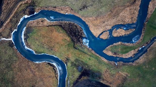
New Research Shows Chaos Shapes How Meandering Rivers Change Over Time
Rivers are rarely the calm, orderly streams we imagine on maps. Over time, their winding paths — called meanders — shift, bend, and occasionally snap off in sudden “cutoff” events that shorten loops and reshape the landscape. While scientists have long suspected that such cutoffs inject a dose of unpredictability into river evolution, a new study published in Communications Earth & Environment demonstrates that these abrupt events are, by themselves, enough to produce chaos in river channels.
Harvard Ph.D. candidate Brayden Noh and NYU Tandon Assistant Professor Omar Wani used a widely-used computational model to explore how meandering rivers evolve over time. This model isolates the essential dynamics: bends migrate laterally in proportion to curvature, and loops are occasionally severed through cutoffs. Other real-world complexities — like sediment transport, bank composition, and vegetation — are treated as secondary, allowing the researchers to focus squarely on the geometry-driven behavior of rivers.
To test the role of cutoffs, the team simulated rivers starting from nearly identical initial shapes, then introduced infinitesimally small perturbations to each of the multiple copies. They tracked how the channels diverged over time by mapping their evolving shapes onto a fixed grid and measuring differences cell by cell. In a striking counterfactual experiment, when cutoffs were disabled, the two channels stayed nearly identical over large time horizons. When cutoffs were allowed, even tiny initial differences grew exponentially, a hallmark of deterministic chaos.
The researchers quantified this sensitivity using the finite-time Lyapunov exponent, a metric from dynamical systems theory that measures how fast nearby trajectories diverge. They found that the rate of divergence depended primarily on the speed at which bends migrated, not on the specific cutoff threshold. In other words, faster meander migration amplifies chaos, while the geometric criteria for triggering a cutoff mostly determine how frequently the river “resets” its local shape.

Importantly, this chaotic behavior was robust across a wide range of initial river geometries. Whether the model started with gentle or pronounced bends, the presence of cutoffs consistently created sensitive dependence on initial conditions. The team also showed that the predictability of a river’s course is bounded: beyond a certain horizon, roughly the number of cutoffs expected in one Lyapunov time, deterministic forecasts of channel position become unreliable.
The study highlights a subtle but powerful insight: continuous meander migration creates gradual stretching of the river planform, while cutoffs act as abrupt topological resets. Together, these processes produce a hybrid system that is both structured and inherently unpredictable. The finding resonates with broader observations of natural rivers, where cutoffs cluster or cascade, triggering sequences of rearrangements along the channel.
While the model is simplified — it does not include full fluid dynamics, sediment heterogeneity, or flood variability — it provides a clear counterfactual experiment: no real river can evolve without cutoffs, but simulations can, revealing the mechanism behind chaotic divergence. This approach connects geomorphology with fundamental concepts from chaos theory, offering a concrete way to quantify a river’s predictability horizon.
Ultimately, the research suggests that some limits to forecasting river evolution are intrinsic. Even in the absence of storms, landslides, or human intervention, the combination of smooth bend migration and occasional cutoffs ensures that lowland rivers retain a degree of inherent unpredictability. For engineers, ecologists, and planners, this work underscores the importance of probabilistic frameworks over deterministic predictions when assessing river migration and floodplain evolution.

NYU Tandon researcher advocates for uncertainty-aware water risk models to improve flood and drought preparedness
Researchers are calling for a more reliable approach to understanding water-related hazards by explicitly accounting for uncertainty in their predictions, arguing this could improve how communities prepare for the risk of floods, droughts, and river-related erosion.
Omar Wani, a hydrologist at NYU Tandon School of Engineering, and co-authors argue in a recent opinion piece published in PLOS Water that many current hydroclimatic hazard assessments have a major flaw: they only give one answer. These models might predict, for example, that a river will flood to 15 feet, but they don't say how confident scientists are in that prediction or what other outcomes are possible.
Wani, who joined NYU Tandon as an Assistant Professor in the Civil and Urban Engineering Department in 2023, leads the Hydrologic Systems Group, which combines statistical and computational methods to study water dynamics in built and natural environments. His group focuses on understanding hydroclimatic risk and enabling more reliable decision-making under uncertainty.
This uncertainty-focused approach is central to Wani and his PLOS co-authors' argument for models that work more like weather forecasts, giving a range of possibilities with probabilities attached. Rather than saying "the water level in the river will reach 15 feet," these models might say "there's an 80% chance of the water level exceeding 15 feet, a 30% chance of it exceeding 18 feet, and a 10% chance of it breaching the 20 feet mark."
The approach has real-world urgency. Approximately 75% of flood-related fatalities occur when people drive into or walk through floodwaters, while climate change is expected to cause additional capacity deficits in stormwater infrastructure, leading to enormous financial losses. Overwhelmed and damaged drainage structures under roads can cost millions to replace.
In research published in Earth Surface Dynamics, Wani and collaborators demonstrated practical applications of this approach, showing how probabilistic models can generate "geomorphic risk maps" that display the probability of riverbank erosion at different locations over time.
Using satellite data from the rapidly-migrating Ucayali River in Peru's Amazon basin, the researchers showed their novel probabilistic approach consistently outperformed traditional predictions. The method combines mathematical models based on river shape and curves with computer simulations that run thousands of different scenarios to explore possible future outcomes.
Apart from the scientific value of this research in improving our understanding of the river systems, such "risk maps are relatively more informative in avoiding false negatives, which can be both detrimental and costly, in the context of assessing erosional hazards," said Wani. Their results showed that probabilistic forecasts assign appropriate probabilities to regions that might erode, avoiding the overconfident binary classifications of traditional approaches.
The implications extend beyond academic research. Behavioral science research shows that people can exhibit loss aversion and risk aversion when making decisions under uncertainty. However, these psychological preferences can only be utilized when the requisite uncertainty information is available.
"To allow for individuals to use these preferences and risk attitudes during hydroclimatic warning or design decisions, people would need to be aware of the uncertainties in quantitative analysis and forecasts," Wani explained.
His group's current work spans from improving the reliability of flood early warning systems for distributed stormwater infrastructure to testing advanced probabilistic algorithms for satellite-based flood damage classification.
The framework represents a shift from seeking the single "most likely" outcome to embracing the full range of possibilities.
The research has immediate practical applications for infrastructure planning, emergency management, and community resilience. As climate change introduces additional uncertainties into the behavior of streams and rivers globally, the researchers argue that probabilistic approaches become increasingly important. The work reflects growing recognition that uncertainty is not a limitation to overcome, but rather crucial information that enables better decision-making.
In addition to Wani, the PLOS opinion piece's authors are Mason Majszak, who is currently working on a Swiss National Science Foundation project as a Postdoctoral Fellow at NYU Tandon and in the NYU Department of Philosophy, Victor Hertel from the German Aerospace Center, and Christian Geiß from the German Aerospace Center and University of Bonn. Funding for the work was provided by the Swiss National Science Foundation.
The Earth Surface Dynamics paper's authors are, in addition to Wani, Brayden Noh from Caltech, Kieran B. J. Dunne from Caltech and Delft University of Technology, and Michael P. Lamb from Caltech. Funding for the research was provided by the Swiss National Science Foundation and the Resnick Sustainability Institute at Caltech under National Science Foundation awards.