
Urban AI Symposium at NYU Tandon Brings Together Global Experts
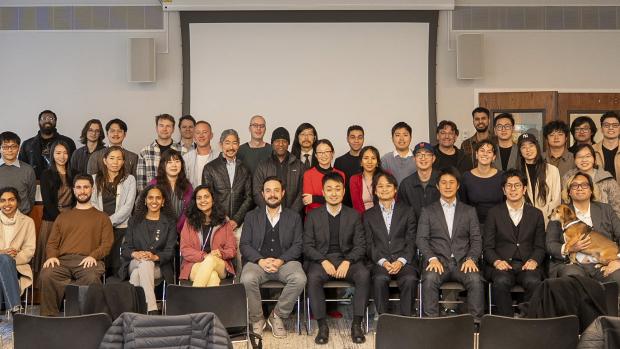
Speakers and participants across academic, government, and private sectors at the Urban AI Symposium.
On October 28th, 2025, the Center for Urban Science + Progress (CUSP) and the Department of Technology Management and Innovation (TMI) at NYU Tandon School of Engineering co-hosted the Urban AI symposium in collaboration with members of the Center for Spatial Information Science (CSIS) at the University of Tokyo. Organized by NYU Tandon Assistant Professor Takahiro Yabe, the event featured a dozen speakers from academic, government, and private sectors.
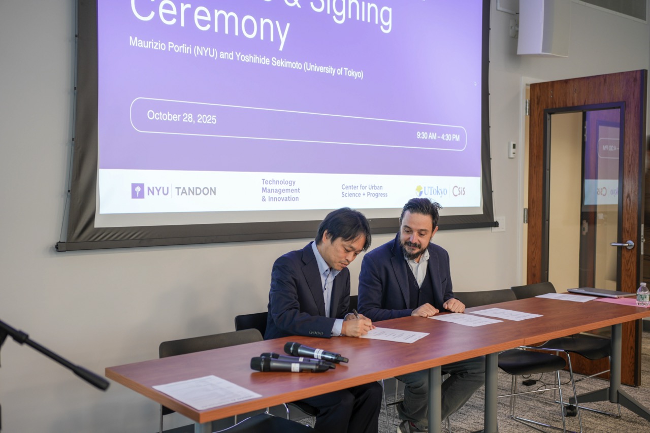
The event began with a signing ceremony celebrating a recently established Memorandum of Understanding between the University of Tokyo and NYU Tandon. Three faculty members from the University of Tokyo — CSIS Director Yoshihide Sekimoto, Yuuki Nishiyama, and Takahiro Yoshida — traveled to New York City for the occasion.
Leveraging Human Mobility Data to Design More Efficient and Resilient Cities
“We have a lot of data on past events and past disasters,” said Yabe. “How can we take an extra step and predict how people will behave in unprecedented shocks — and use these predictions to inform policy design and interventions?”
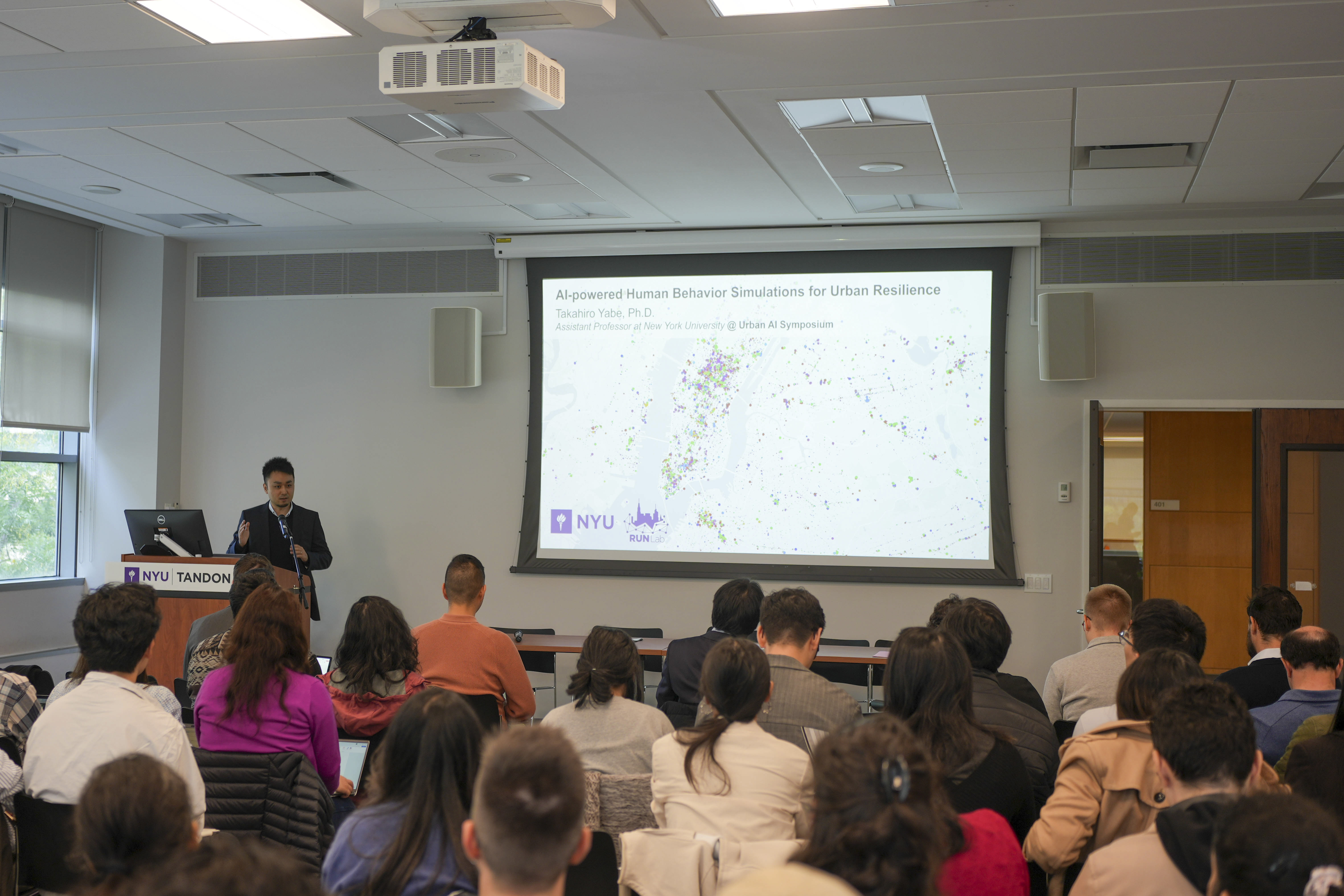
At NYU Tandon, Yabe directs the Resilient Urban Networks Lab, which is developing a wide range of approaches — including generative, causal, and counterfactual behavior simulations — to analyze impacts at both individual and collective levels. During his talk, AI-powered Human Behavior Simulations for Urban Resilience, Yabe emphasized the abundance of human behavior data that’s available today, and discussed how his lab leverages it to predict future scenarios.
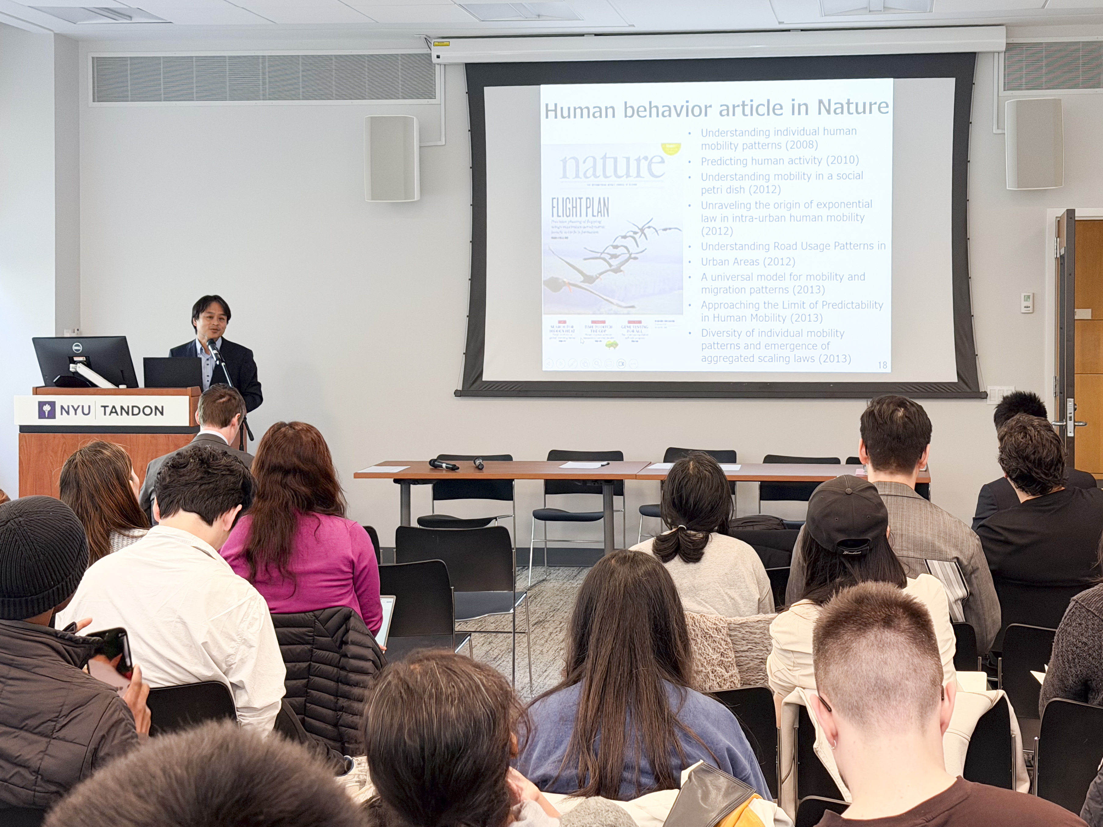
In a related effort, Yoshihide Sekimoto, Professor at the University of Tokyo, highlighted a collaboration with the City of Kobe in which synthetic mobility datasets developed as part of the People Flow Project (PFLOW) were used to identify sites for a bus service expansion project. The resulting routes were implemented in July 2025. PFLOW provides synthetic, Japan-wide human mobility data — a valuable resource for researchers seeking alternatives to private-sector GPS datasets, which are often costly and subject to privacy regulations.
Innovations in Public Health and Safety
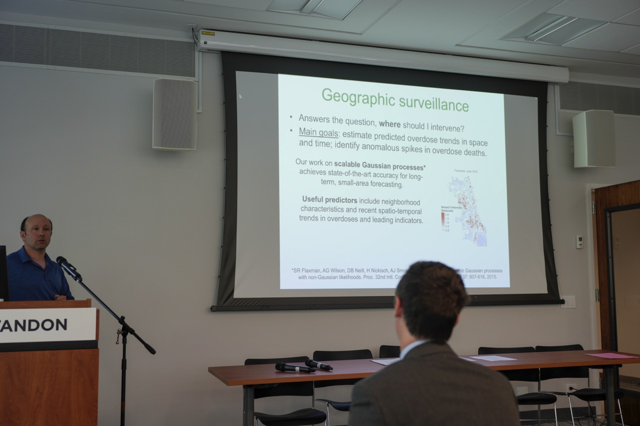
“Machine learning has great potential to save lives,” said Daniel Neill, Professor at CUSP, NYU Wagner, and NYU Courant, in reference to his ongoing research confronting the opioid crisis. “We can detect subtle and emerging patterns of overdose and opioid use disorder in the early stages and use that to target effective public health responses.” Neill, who leads the Machine Learning for Good Laboratory, discussed how he’s working with the State of Rhode Island to predict overdose risk at high spatial resolutions.
Yuuki Nishiyama, Associate Professor at the University of Tokyo, described how he is using GNSS (Global Navigation Satellite System) signals collected on smartphones to measure UV exposure risk with greater precision. His research reveals how UV attenuation varies across cities, depending on variables such as building shadows and tree coverage.
Danny Huang, Assistant Professor at CUSP and in the Departments of Electrical and Computer Engineering (ECE) and Computer Science and Engineering (CSE) at NYU Tandon, introduced RouterSense, a software that monitors everyday internet use. Huang and researchers at his mLab have already piloted a study with 25 NYU students, and are now partnering with collaborators to apply the technology to detect early signs of Alzheimer's. The tool was designed to be as inconspicuous as possible: users connect via a VPN peer or Raspberry Pi-powered device plugged into their router, with no additional steps required.
“It’s a system for continuous behavior monitoring that is unobtrusive, restricts privacy, and that is low-cost to scale out because we are not using anything else other than what’s already there,” explained Huang.
Finally, Paul Torrens, Vice Dean of Faculty Affairs and Professor in the Department of Computer Science and Engineering and at CUSP at NYU Tandon, presented research on using AI to examine the dynamics of pedestrian behavior. Under Torrens’ direction, the SimSpace Lab is exploring how to uncover embodiment in pedestrian geography by capturing both visual data — body language and expressions — as well as EEG signals from brain-computer interfaces. Their findings show that embodiment forms a key link between urban science and behavior that could be used to inform the creation of pedestrian AI world models that more accurately mirror human cognitive processes.
Deploying Tools for Public Action
Jiahao Chen, Director of Artificial Intelligence and Machine Learning at New York City’s Office of Technology and Innovation who manages the implementation of New York City’s Artificial Intelligence Action Plan, emphasized the City’s role as a global leader in AI and data-driven innovation.
“New York City is one of the first governments in the world to publicly report what kind of algorithmic tool that has a public impact, and of course that includes AI,” said Chen as part of his talk Responsible AI innovation in City Government.
Cláudio T. Silva, Institute Professor in the Department of Computer Science and Co-director of the Visualization Imaging and Data Analysis (VIDA) Center at NYU Tandon, presented several projects including CitySurfaces, a tool that provides researchers and city agencies with a method for collecting sidewalk material data to inform sustainability and accessibility-related policies and initiatives. He also discussed StreetAware, a project that combines audio, video, and LiDAR data from urban intersections to develop insights on accessibility and safety.
“We wanted to reconstruct what happens at an intersection,” said Silva. “The problem is that you often need multiple camera views. So we built a piece of hardware with synchronized video and audio capabilities. You can put a bunch of them on the street for multiple streams of data.”
According to Silva, projects like this aim to address shortfalls in information. “Data gaps are not inevitable. We can solve them if we work together to build new tools.”
Takahiro Yoshida, Assistant Professor at the University of Tokyo, presented Spatial Data Analysis for Climate Change and Cities, highlighting methods that leverage remote sensing and social media data to map carbon emissions and individual-level heat risk with greater precision.
Alexander Robel, Associate Professor at Georgia Institute of Technology, and Charlie Mydlarz, Research Associate Professor at CUSP and Technical Lead at FloodNet NYC, discussed the topic of flooding from complementary angles. Robel presented Community Engagement as Optimization For ML-based Design of Flood Mitigation Infrastructure, exploring how the perspectives of residents impacted by flooding can be meaningfully incorporated into machine learning models. Mydlarz introduced FloodNet NYC, a real-time urban flood monitoring system. The system relies on a network of ultrasonic sensors mounted on street utility infrastructure to measure the distance to the ground surface below. The sensors inevitably encounter interference, such as debris, so the team relies on AI models to filter out noise and determine the actual water depth.
The symposium concluded with a talk by Willa Ng, who works on product strategy for Google Earth. She pointed to earlier speakers who had cited Google’s tools in their research, and presented a demo of Google Earth AI, including how to prompt it to identify hotspots.
By bringing together boundary-pushing researchers, companies at the forefront of geospatial AI innovation, and government workers advising AI policies, this symposium fostered a more complete conversation on the role of emerging technologies in urban environments and set the stage for cross-sector collaborations.