NYU Tandon and Wagner project to look below the surface to make NYC more resilient
Unification for Underground Resilience Measures (UNUM), which received a second-stage NSF City Innovation Challenge award, will help communities respond to storms, floods, and other disasters by making underground infrastructure data viewable and shareable.

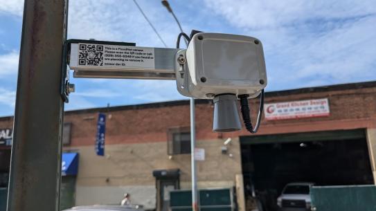
BROOKLYN, New York, Tuesday, October 5, 2021 — Recent storm-related flooding in New York City from Ida and Henri demonstrates the need for comprehensive, quickly accessible data about the spatial relationships between utility conduits, water and waste systems, fuel transit pipelines, transportation tunnels, and other infrastructure beneath our feet. Whether a crisis involves a fire from a gas leak, flooding that overwhelms drainage systems, electricity outages, or any emergency requiring crews to access subsurface equipment, with potentially hazardous proximity to other systems, easily accessible, usable data about what they are likely to encounter could expedite service restoration and increase safety.
Debra Laefer, Professor in the Department of Civil and Urban Engineering and the NYU Center for Urban Science and Progress (CUSP) at the NYU Tandon School of Engineering, and Rae Zimmerman, Research Professor and Professor Emerita of Planning and Public Administration at NYU Wagner, have received a $1 million Civic Innovation Challenge (CIC) Award supporting community-based solutions to mobility and disaster resilience. The Stage 2 Award will further a collaborative project launched earlier this year supported by a $50,000 CIC Stage 1 Award, to address this challenge by creating a digitized, open, underground infrastructure road map.
Funded by the National Science Foundation (NSF) and the Department of Homeland Security, the project, Unification for Underground Resilience Measures (UNUM), brings together a consortium of utility companies, city agencies, and consultants, with a focus on Sunset Park, Brooklyn, and Midtown East, Manhattan. The two neighborhoods will serve as testbeds for city-level implementation of a subsurface data model to assemble data sets to prepare study sites against natural disasters.
Co-led with Wendy Dorf and Alan Leidner from NYC’s Geospatial Information System and Mapping Organization (GISMO), UNUM will employ the Model for Underground Data Definition and Interchange, an open modeling framework for standardizing underground utility information led by the Open Geospatial Consortium (OGC), a global consortium of 500 businesses, government agencies, research organizations, and universities united with a desire to make location information open and accessible and usable.
UNUM is supported by expertise and feedback from community stakeholders including:
- Eric Adams, The Brooklyn Borough President’s Office
- Gale Brewer, the Manhattan Borough President’s Office
- Stephen Levin, member, council district 33
- Keith Powers, member, City council district 4
- Jeremy Laufler, Chair, Community Board 7
- Alexandra Sica, president, the DUMBO Business Improvement District
- Mark Baldovin, gas lead, Con Edison
- David LaShell, manager for New York, ESRI
- Alfred C. Cerullo, III, President/CEO, Grand Central Partnership
- Verizon
“We are refining strategies for data sharing by making critical information on community infrastructure robust, open, transparent, and easy for key stakeholders to share and act upon, so they can be applied across multiple jurisdictions throughout the U.S. in order to help cities nationwide assess threats and vulnerabilities of vital infrastructure systems,” said Laefer. “If everyone has access to a digitized data standard such as that developed by OGC, then within hours, if not minutes, that data should be easily aggregated or interoperable.”
“Much of the time data about the state of infrastructure is held in proprietary systems, stored in separate silos, and likely to be in incompatible formats,” explained Laefer. “The goal is a seamless, interoperable, 3D data storage and visualization system and a way for communities, utilities, and others to share data with appropriate security and privacy measures in place.”
Zimmerman noted that catastrophic flooding events have often overwhelmed the capability of drainage to divert floodwaters resulting in inundated underground rail lines, flooded and undermined roads, and halted electrical and communication systems, with untold societal and economic consequences.
“Our project aims to strengthen society’s infrastructure resiliency to confront the complexity and interconnectivity of the vast infrastructure below and above ground engaging stakeholders to develop a roadmap for shared data with their inputs,” she said. “The goal of increasing resilience would enable infrastructure systems to resist, reduce, and recover from infrastructure destruction in underground infrastructure and cascading to others. It provides a scalable, transferrable framework for secure infrastructure data sharing through collaboration, which is an imperative for infrastructure policy, management, and planning. The two pilot areas provide important contrasts in their experiences in resisting and recovering from underground infrastructure disruptions and differ in their social and economic resilience in the face of such disruptions.”
The National Science Foundation, in partnership with the U.S. Department of Homeland Security and the U.S. Department of Energy, offered the Stage 2 grants to 17 U.S. teams out of the 50 who received the Stage 1 grant in February this year. The grants go to collaborations comprising civic partners such as local, state, and tribal officials and non-profit and community leaders to conduct and evaluate ready-to-implement pilot projects that address community-identified challenges.
“We applaud the efforts of all the teams who worked tirelessly to build partnerships between researchers and community stakeholders,” said NSF Director Sethuraman Panchanathan, in an NSF statement.
About the New York University Tandon School of Engineering
The NYU Tandon School of Engineering dates to 1854, the founding date for both the New York University School of Civil Engineering and Architecture and the Brooklyn Collegiate and Polytechnic Institute. A January 2014 merger created a comprehensive school of education and research in engineering and applied sciences as part of a global university, with close connections to engineering programs at NYU Abu Dhabi and NYU Shanghai. NYU Tandon is rooted in a vibrant tradition of entrepreneurship, intellectual curiosity, and innovative solutions to humanity’s most pressing global challenges. Research at Tandon focuses on vital intersections between communications/IT, cybersecurity, and data science/AI/robotics systems and tools and critical areas of society that they influence, including emerging media, health, sustainability, and urban living. We believe diversity is integral to excellence, and are creating a vibrant, inclusive, and equitable environment for all of our students, faculty and staff. For more information, visit engineering.nyu.edu.
About NYU Wagner
NYU's Robert F. Wagner Graduate School of Public Service prepares public service leaders to translate ideas into actions that have an effective and lasting impact on the public good. Our faculty’s research changes the way people frame, understand, and act on important public issues. We provide our students with critical skills, access to all that New York City has to offer, and a deep understanding of context surrounding public service challenges — which they use to improve cities and communities across the globe. Since 1938, NYU Wagner has been educating the world’s future public service leaders. We offer a Master of Public Administration in Public & Nonprofit Management & Policy, Master of Public Administration in Health Policy & Management, Master of Urban Planning, Master of Health Administration, Master of Science in Public Policy, Executive Master of Public Administration, and Ph.D. in Public Administration.