New York City's flood sensors inspire global networks to monitor street-level flooding
FloodNet technology spreads beyond NYC as communities seek real-time flood data

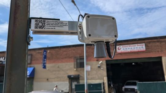
FloodNet sensor in lower Manhattan. Photo credit: Devon Preston.
A low-cost New York City street flood monitoring system is being adapted by scientists worldwide, demonstrating how open-source technology provides a blueprint for communities to efficiently track urban flooding from New Jersey to Brazil and Puerto Rico.
FloodNet was developed through a collaboration between NYU Tandon researchers Andrea Silverman and Charlie Mydlarz, CUNY researchers at the Advanced Science Research Center, Brooklyn College, and the Science and Resilience Institute at Jamaica Bay, together with NYC government agencies and community organizations.
Among the largest street-level flood monitoring networks in the United States, FloodNet has received $7.2 million in city funding and deployed over 265 sensors across all five boroughs since 2020, with plans for 500 by 2028 to monitor floods from extreme rain, rising sea levels, and storm surge.
The expansion comes as flooding poses an escalating threat that traditional monitoring systems often struggle to handle. The New York City Department of Health and Mental Hygiene's Jurisdictional Risk Assessment 2024 identified flooding as the most pressing public health risk for the city. A study published in Communications Earth & Environment found flood days in North Carolina “an order of magnitude greater” than official tide gauge projections indicated, underscoring the limitations of conventionally-available flood data.
FloodNet was designed to fill this monitoring gap. While ultrasonic sensors have been used for flood monitoring before, existing systems focus primarily on rivers, streams, and other waterways, not the street-level flooding that directly impacts where people live, work, and travel. According to a paper by FloodNet researchers in Water Resources Research, there are "limited examples of such systems being deployed at street-level on a city-wide scale," making FloodNet's urban-focused approach uniquely valuable.
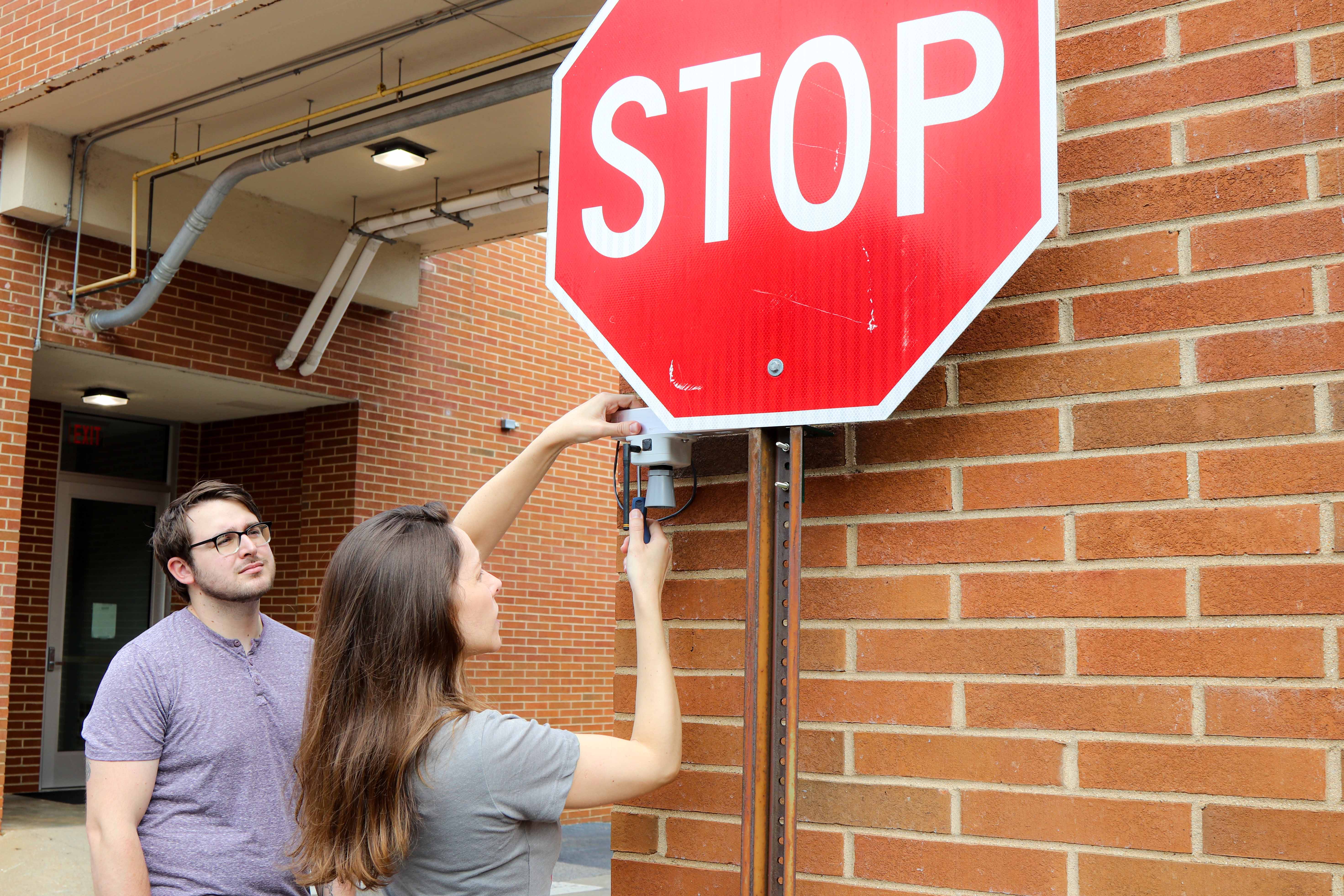
The FloodNet sensors are compact, rugged and deployed independently of existing urban power and network infrastructure. Each solar-powered sensor uses an industrial-grade ultrasonic range-finder that transmits inaudible sound waves to measure water depth to within one inch, collecting data every minute and transmitting it wirelessly over LoRaWAN or cellular networks. At under $300 per unit, the sensors cost a fraction of traditional flood monitoring equipment.
The FloodNet team has made sensor design files open source on GitHub alongside its free public dashboard displaying real-time flood data, enabling researchers worldwide to adapt the technology. The system is already used by New York City agencies, including Emergency Management and the Department of Environmental Protection.
One of the most ambitious adaptations is just starting in Puerto Rico, where University of Georgia researcher Felix Santiago-Collazo is leading a National Science Foundation-funded project to deploy 30 FloodNet sensors in San Juan. The project goes beyond simple flood detection to create what Santiago-Collazo calls "impact-based forecasting," providing specific information: "Based on a rainfall forecast, a certain street could be flooded from this time to this time. Thus, take the following route to avoid disruptions in your commute."
"We want to make flood models in collaboration with the community," Santiago-Collazo said. "They are the ones that know where and how much it floods during rainfall and hurricane events. They're the ones living it, not us." The sensors will be built by local college and high school students through STEM workshops.
In a separate project, Santiago-Collazo is working with doctoral student Luciana Iannone Tarcha to bring FloodNet technology to São Paulo, Brazil. Tarcha plans to work with Dr. José Rodolfo Scarati Martins, who manages São Paulo's existing flood sensor network along rivers. The new sensors would detect street-level flooding in urban areas where drainage systems may be failing.
In Rhode Island, Brown University researcher Sol Cooperdock runs the BEST (Brown Environmental Sensing Technologies) Network and has deployed 13 flood monitoring sensors using FloodNet as a model in port communities including Providence and Narragansett. This work is part of the Community-Driven Coastal Climate Research and Solutions (3CRS) Hub project that also extends to Maine.
Closer to home, Drexel University's Franco Montalto has used FloodNet sensors in Camden, N.J., since 2019 as part of another NSF-funded project . "We're using the FloodNet data to calibrate and validate hydrologic and hydraulic models that we use to simulate flood risks," Montalto said. He also wrote about the value of FloodNet sensors in a report on flooding he co-authored for the New York City Panel on Climate Change, which he currently co-chairs.
In South Florida, Georgios Sklivanitis and Dan Zimmerman at the Center for Connected Autonomy and AI at Florida Atlantic University developed "FloodSense," an end-to-end platform for hyperlocal sensing and AI data analysis that built upon the open-source sensor design of FloodNet to enable near real-time forecasting of coastal flooding. The project engaged multiple municipalities in areas where "flooding is something that we deal with almost every day even when it's not raining due to high tides."
The need for better flood monitoring becomes apparent when considering infrastructure designed for different conditions and the impact of climate change on communities. "Most people in New York have no idea this is happening," said Silverman – FloodNet's principal investigator who serves as a NYU Tandon Institute Associate Professor in the Civil and Urban Engineering Department and a faculty member of the Center for Urban Science + Progress — referring to the city's chronic flooding problem.
"The neighborhoods around Jamaica Bay flood every month, sometimes 7 times a month." This regular flooding reveals how sea level rise is already impacting the day to day lives of some NYC communities .
FloodNet's open-source approach offers a scalable model for communities to understand and respond to their flood challenges, transforming an innovation developed by NYU and CUNY for New York City into a global tool for urban resilience.