

A New Physics-informed AI Tool Aims to Predict Wildfire Spread in Real Time and Assist Wildfire Response
NYU’s digital twin system, which merges physics with artificial intelligence, can forecast fire spread within minutes rather than days, giving fire departments and incident commanders a faster way to assess changing wildfire conditions.
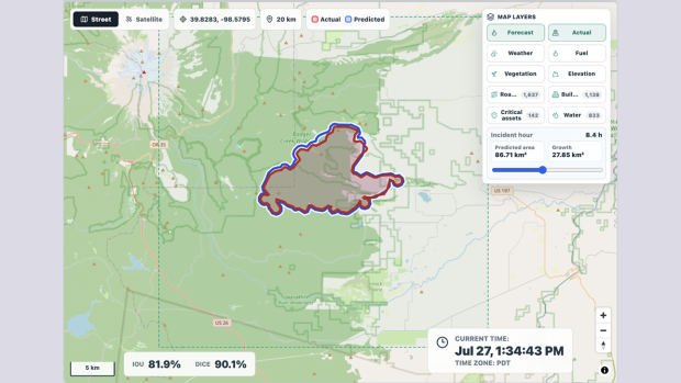
Fig: Screenshot from NYU’s Digital Fire Twin prototype showing a near-real-time wildfire spread forecast generated approximately three hours before the observed fire perimeter for Grasshopper Fire, Oregon. The blue outline shows the model-predicted fire perimeter, the red outline shows the actual observed perimeter, and the overlap metrics indicate strong agreement between the forecast and observed fire spread.
A new AI system that NYU Fire Research Group describes as a digital twin of an active wildfire has, in early testing, shown the ability to forecast how a fire will spread in near real time.
It continuously updates its forecast as new data arrives from satellites, weather feeds, terrain, fuel, wildland–urban interface, structures, critical infrastructure, vegetation maps, drones, ground sensors, and crews in the field.
The lead research team, comprising Research Associate Professor Prabodh Panindre, Research Scientist Anandu Nair, and Global Network Professor Sunil Kumar, says the system is designed to address one of the most urgent challenges in wildfire response: giving incident commanders timely, explainable forecasts as fire conditions change.
The platform displays a U.S. map on which a user picks a fire location, sets the size of the area to forecast, and chooses a time horizon of up to 12 hours, updated at set intervals. The map then shows the predicted perimeter of the fire’s spread under those criteria.
An AI-enabled plain-language interface, similar to a chatbot, lets users ask direct questions, such as what happens to the eastern flank if the wind shifts north, where to cut a firebreak, or which zones to evacuate first. It recommends containment strategies, evacuation plans, and training scenarios, citing fire department procedures and published research so commanders can review the reasoning behind its advice.
The system works by pairing a physics-informed fire-spread model with an AI layer that continually solves equations governing fire propagation, combustion, heat transfer, fuel type and properties, wind, slope, weather, and known fire-transition thresholds, using live conditions rather than relying only on historical fire data, as many machine-learning tools do.
“Our system is not built from training data. It is grounded in physics,” Kumar said, who like Panindre, holds appointments at NYU Abu Dhabi and NYU Tandon School of Engineering. “We solve the fundamental equations of how fire burns and spreads using AI, instead of solving them only in the conventional way.”
Physics-based simulators can be accurate but computationally intensive, often taking hours to update as conditions change. Machine-learning tools can be faster but are only as strong as their training data and may struggle under conditions they have not seen before.
The digital twin is designed to combine the strengths of both approaches, continuously synchronizing with new observations to produce updated forecasts in near real time. The researchers have filed a provisional U.S. patent through NYU.
The team tested the system on three active wildfires: Oregon’s Grasshopper Fire, Utah’s Widemouth 2 Fire and New Mexico’s Sacaton Fire. In one test involving the Grasshopper Fire, the predicted and observed fire areas achieved a 94.6 percent match using a standard measure of spatial overlap. Other tests showed varying results, with agreement declining to 72.4 percent in one Grasshopper Fire forecast following a longer gap between satellite observations.
What impressed the researchers most, they said, was not simply how much area the system predicted correctly, but the shape of its forecasts. Rather than approximating a fire as a rough circle, the model reproduced the irregular, jagged edge traced by the real wildfire across the landscape.
That distinction matters operationally, Panindre said, because a fire's exact boundary determines where incident commanders deploy crews and which neighborhoods they evacuate.
“A small difference on a map may not look very significant,” Panindre said, “but it may be very significant in real life, because there may be a critical structure there.”
The system remains a research prototype and has not yet been deployed as an operational tool on active wildfires. Panindre said the team wants further testing with fire departments and federal agencies before making it public.
“Whatever we do, we try to make sure that there is an impact in terms of saving lives,” Panindre said. “That has been the focus of Sunil’s and my research for the last 20 years.”

Prabodh Panindre
