Takahiro Yabe
,
Ph.D.
-
Assistant Professor

Dr. Takahiro Yabe is an Assistant Professor at the Department of Technology Management and Innovation (TMI) and the Center for Urban Science + Progress (CUSP).
His research focuses on computational social science and network science approaches to model the resilience of cities to disasters, pandemics, and disruptive mobility technology, and has been published in journals including Nature Human Behaviour, PNAS, Nature Communications, and Nature Machine Intelligence. Previously, he was a Postdoctoral Associate at the MIT Institute of Data, Systems and Society (IDSS) and the MIT Media Lab with Alex 'Sandy' Pentland and Esteban Moro. He obtained his Ph.D. from Purdue University in 2021, and his MS and BS from the University of Tokyo in 2017 and 2015, respectively.
Urban Resilience
Human Mobility
Inequality and Segregation
Socioeconomic Networks
Education
Postdoc, Massachusetts Institute of Technology (2021 – 2023)
Ph.D., Purdue University (2017 – 2021)
MS, The University of Tokyo (2015 – 2017)
Bachelor of Engineering, The University of Tokyo (2011 – 2015)
Selected Awards and Grants
- Nice Step Researcher Award (2024), Ministry of Education, Culture, Sports, Science and Technology of Japan
- Emerging Award (2024), Complex Systems Society
- Vice Presidential Unit Award (2022), The World Bank, to GFDRR mobility data analytics team
- Top 10% Citation Award (2021), PLoS ONE, for “Cross-comparative analysis of evacuation behavior after earthquakes using mobile phone data”
- Doctoral “Systems” Fellowship (2018 – 2020), Purdue University
- STV Civil Engineering Graduate Assistantship Endowment Award (2020), Lyles School of Civil Engineering, Purdue University
Selected Publications
- Yabe, T., Bueno, B. G. B., Dong, X., Pentland, A., & Moro, E. (2023). Behavioral changes during the COVID-19 pandemic decreased income diversity of urban encounters. Nature Communications, 14(1), 2310.
- Yabe, T., Rao, P. S. C., Ukkusuri, S. V., & Cutter, S. L. (2022). Toward data-driven, dynamical complex systems approaches to disaster resilience. Proceedings of the National Academy of Sciences, 119(8), e2111997119.
- Yabe, T., Jones, N. K., Rao, P. S. C., Gonzalez, M. C., & Ukkusuri, S. V. (2022). Mobile phone location data for disasters: A review from natural hazards and epidemics. Computers, Environment and Urban Systems, 94, 101777.
- Yabe, T., Tsubouchi, K., Fujiwara, N., Sekimoto, Y., & Ukkusuri, S. V. (2020). Understanding post-disaster population recovery patterns. Journal of the Royal Society Interface, 17(163), 20190532.
- Yabe, T., Tsubouchi, K., Fujiwara, N., Wada, T., Sekimoto, Y., & Ukkusuri, S. V. (2020). Non-compulsory measures sufficiently reduced human mobility in Tokyo during the COVID-19 epidemic. Scientific reports, 10(1), 18053.
Research News
Research reveals economic ripple effects of business closures, remote work and other disruptions
With remote and hybrid work now an established norm, many restaurants located adjacent to office buildings are facing a permanent decline in foot traffic. But how will this behavioral shift ripple through businesses along commute routes? Does it trigger a chain reaction that extends far beyond the immediate vicinity of a commercial hub?
In a new paper published in Nature Human Behavior, a team of researchers led by NYU Tandon School of Engineering’s Takahiro Yabe and Northeastern University’s Esteban Moro have shown how connections between businesses stretch far beyond proximity when human behavior data is factored into the equation. The result shows that businesses — from gas stations to laundromats — can see large changes in their revenues, even if they're not located in major business districts.
“Urban science views cities as complex adaptive systems, rather than entities that can be engineered with straightforward solutions,” says Yabe, Assistant Professor at the Department of Technology Management and Innovation and the Center for Urban Science and Progress. “Our research contributes to understanding how changes in urban environments influence human behavior and economic dynamics. By focusing on dependencies between businesses and points of interest, we can help cities design more effective, equitable policies and infrastructure.”
Traditional models for measuring interdependence of businesses largely rely on their physical proximity to one another. The research team, which also included researchers from the University of Pittsburgh and MIT — analyzed anonymized mobile phone data from over a million devices across New York, Boston, Los Angeles, Seattle, and Dallas, tracking how people move between businesses and other points of interest throughout the day. This allowed researchers to create detailed "dependency networks" showing how different establishments rely on each other's customer base – and how far disruptions can spread.
This integration allowed them to refine predictions of business resilience during disruptions — such as those triggered by the COVID-19 pandemic — boosting accuracy by a staggering 40% compared to traditional models that relied solely on geographic proximity.
These networks revealed surprising patterns. While traditional models focused mainly on immediate neighbors – like a coffee shop next to a closed office building – the reality is far more complex. The study found that airports can significantly impact businesses up to 2.5-3.5 kilometers away, while even supercenters and colleges influence businesses within a 1.5-kilometer radius.
The researchers were also able to show how different types of establishments create varying ripple patterns. While shopping malls and colleges tend to have strong but localized effects, airports, stadiums, and theme parks can send economic shockwaves across entire urban areas. Perhaps most surprisingly, arts venues, restaurants, and service businesses can experience substantial impacts even when they're far from the source of the disruption. This can provide key takeaways for people to design and run cities.
“This network has significant potential for urban planners and policymakers,” says Yabe. “For example, organizations like Business Improvement Districts (BIDs) can use it to identify synergies between parks and surrounding businesses, optimizing economic growth. Planners can also simulate the impacts of interventions, like congestion pricing or new infrastructure, to anticipate ripple effects throughout the city.”
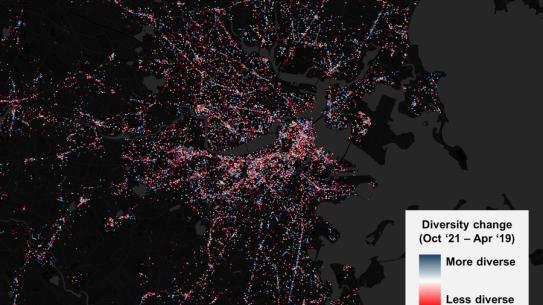
The publication is accompanied by an interactive visual dashboard, inviting users to simulate disruptions and observe how they impact a city’s economic landscape. Through a detailed map of POI’s in Boston, users can see exactly how much connectivity individual businesses have with those in their communities and beyond, and explore how business closures affect points far beyond their blocks or neighborhoods.
This research builds upon previous research of Yabe and his colleagues. Last year, they started a National Science Foundation-funded project on how EV chargers affect dining, shopping, and other activity patterns, and aim to provide policy makers with tools to support small and medium-sized businesses through their judicious placement. The project explores how and where charging stations should be placed to not only meet drivers’ needs but also enhance the economic resilience of local businesses and promote social equity.
The improved accuracy of business resilience predictions during disruptions such as pandemics or climate change-induced natural disasters is a crucial development for urban planners and policymakers working to strengthen the economic stability of cities. This insight makes a compelling case for shifting from a place-based to a network-based approach to planning and managing urban economies — one that recognizes that the health of a city's economy is a web of interconnected threads. The closure of an office or museum may seem like an isolated event, but within the tightly woven fabric of urban economies, it can reverberate with far-reaching effects.
Towards open and standardized human mobility data: NYU Tandon researchers address key challenges and solutions
Despite the vast amounts of human mobility data generated by smartphones, a lack of standardized formats, protocols, and privacy-protected open-source datasets hampers innovation across various sectors, including city planning, transportation design, public health, emergency response, and economic research. The absence of established benchmarks further complicates efforts to evaluate progress and share best practices.
Takahiro Yabe, assistant professor at the Center for Urban Science + Progress (CUSP) and Department of Technology Management and Innovation at NYU Tandon, recently collaborated with a team of researchers — Massimiliano Luca (Fondazione Bruno Kessler), Kota Tsubouchi (LY Corporation), Bruno Lepri (Fondazione Bruno Kessler), Marta C. Gonzalez (University of California, Berkeley), and Esteban Moro (Northeastern University) — to advocate for the necessity of open and standardized human mobility data. Their opinion piece, published in Nature Computational Science, builds upon the recent release of the open-source, anonymized, large-scale human mobility dataset YJMob100K developed by several authors of this paper.
"The creation of the YJMob100K dataset and associated HuMob Challenge 2024 was motivated by our concern that similar human mobility datasets are exclusive to select researchers and industry organizations," said Yabe.
Unpacking the complexities of human mobility data pre-processing
Tracking a journey from origin to destination using mobile phone data is not straightforward. Data can vary significantly depending on the application employed, and datasets may not capture all transit modes. Inconsistencies in definitions, classifications, and data tags can introduce biases.
For example, defining what constitutes a "stop" — whether it’s a pause of 5 minutes, 30 minutes, or an hour — can be somewhat subjective. “To detect a stop within a mobility trajectory, data scientists need to define arbitrary hyperparameters such as the minimum number of minutes spent at the stop and the maximum movement distance allowed from the stop centroid,” noted the authors. “With several hyperparameters needed for each pre-processing step, a slight change in the selection of these parameters could result in a very different processed human mobility dataset.”
Pre-processing human mobility data is critical for protecting individual privacy. However, the methods used in this process are often kept confidential, creating a "black box" problem that raises concerns about data validity and accuracy. To address these issues, companies evaluate datasets by comparing them with external sources such as census data. However, researchers aiming to introduce and evaluate new methods for predicting human mobility continue to face a significant hurdle: there is currently no standard open benchmark dataset.
Advancing human mobility research with the YJMob100K dataset
The authors propose two strategies for approaching this challenge: creating synthetic, privacy-preserving human mobility datasets using machine learning models, or anonymizing a large-scale mobility dataset through collaboration with a private company. The latter strategy was employed for YJMob100K, which was developed through a collaboration involving Takahiro Yabe from NYU Tandon, Yoshihide Sekimoto and Kaoru Sezaki from the University of Tokyo, Esteban Moro and Alex Pentland from MIT, along with Kota Tsubouchi and Toru Shimizu from the private Japanese internet company LY Corporation.
The YJMob100K dataset was anonymized by converting location pings into 500x500 meter grid cells and aggregating timestamps into 30-minute intervals while masking the actual dates. Individuals who contributed data signed a consent form outlining the frequency and accuracy of location data collection as well as its intended use. All data processing and analysis were conducted on servers managed by the company.
To promote the dataset, the authors initiated the Human Mobility Prediction Challenge (HuMob Challenge) in 2023, which is currently underway for its second year. Selected entries will be showcased at the ACM SIGSPATIAL conference, taking place in Atlanta from October 29 to November 1, 2024.
"Inspired by advancements in natural language processing models like transformers, many submissions in the 2023 edition used AI and machine learning approaches," said Yabe. "Eight of the top ten submissions used deep learning techniques. With over 85 teams and 200 participants from 22 countries, the overwhelming response motivated us to continue into 2024. This year's challenge is more advanced, targeting predictions for cities that lack data."
The authors have identified several key challenges they aim to address in their future work. First, they aim to establish criteria for creating “fit-for-purpose” benchmarking datasets to achieve consensus within the research community. This involves defining clear metrics for data specification and establishing industry standards for pre-processing. Second, recognizing that different tasks require different types of data, they propose creating a collection of “fit-for-purpose” datasets, each tailored to specific research domains, communities, and socio-spatial-temporal contexts. This necessitates a bottom-up approach led by relevant research communities to ensure the datasets are well-aligned with their intended uses.
Yabe, T., Luca, M., Tsubouchi, K., Lepri, B., Gonzalez, M. C., & Moro, E. (2024). Enhancing human mobility research with open and standardized datasets. Nature Computational Science, 4(7), 469-472. https://doi.org/10.1038/s43588-024-00650-3


