Our Engineers Remember Superstorm Sandy and Its Lessons

A subway station flooded by Superstorm Sandy. Photo: Metropolitan Transportation Authority/Patrick Cashin
Five years ago Sandy swept the entire seaboard of the U.S., saving its worst for the coastal areas of New Jersey and New York. Seawater from the surge filled streets and subway tunnels, and water deluged a substation on Manhattan’s East Side, cutting power to a million people.
Sandy’s price tag to New York City was an estimated at nearly $42 billion, including more than $4.7 billion in damages to New York City subway and train tracks, tunnels and stations. Con Edison has spent $1 billion to harden its networks, and the city has spent $5 billion in the five years since Sandy on recovery and resiliency projects with $7 billion more planned in coming years.
Offering their perspectives on the city’s progress are four experts at the NYU Tandon School of Engineering who are involved in the effort to make our area more resilient and better prepared by analyzing vulnerabilities and locating opportunities for improvement in the power grid, transportation, public/private collaborations, storm protection and more.
Kaan Özbay

A professor in the Department of Civil and Urban Engineering and director of NYU’s Connected Cities for Smart Mobility toward Accessible and Resilient Transportation (C2SMART) Center, Ozbay — who recently garnered the 2017 Franz Edelman Finalist Award as part of a team that is composed of the New York City DOT, Rennsealer Polytechnic Institute and Princeton University — is an expert on modeling complex transportation scenarios around weather-related evacuations.
How accurate and useful is evacuation modeling for hurricanes?
The state of practice needs to improve because current models assume average capacity and demand for a so-called typical day. Our research shows the most important change needed to improve these models for events like storms, where weather conditions can affect evacuation routes, would be to incorporate link capacity failures due to such events as accidents, trees down, and flooding.
How realistic is it to attempt to evacuate a metropolitan population like New York’s to points west in a relatively short time?
It isn’t. First, the city has limited alternatives to evacuate people outside the city to places like New Jersey, given that we have only a couple tunnels and bridges to the west. Realistically, the only way to deal with that is to give evacuation notices earlier than usual. For authorities making such decisions, real-time evacuation models using the most up-to-date storm information can be valuable tools.
Evacuation models are theoretical, but how can they be applied practically, in a real-time sense?
Today we have the computational power, software, and data to do quasi real-time decision making: we can run evacuation models right before we need to evacuate, and modify evacuation plans based on the most up-to-date models. This is similar to the weather models we run to predict the path of hurricanes. In fact, Tandon researchers have proposed a novel framework that will combine weather models with evacuation models.
Isn’t human behavior the big “if” in evacuation? According to data from the New York City Department of Health and Mental Hygiene nearly 50 percent of people in some evacuation areas stayed put during Sandy.
Generally, there is too little data on evacuation behavior, especially in our region, because hurricanes are rare events in the the Northeast. But some things we do know. For example, people are less apt to evacuate if their last encounter with a hurricane was comparatively uneventful. Big data collected during evacuation operations can be used to better understand human behavior under such conditions.
Yury Dvorkin

A professor in NYU Tandon’s Department of Electrical and Computer Engineering, Yury Dvorkin is an expert in smart grids, including renewable generation, storage, smart appliances, and cyber infrastructure. He is currently working on a National Science Foundation-funded project that aims to enhance power grid resiliency in the wake of Hurricane Harvey.
The Hurricane Sandy surge swamped a major power substation in Manhattan. What are utilities and the state doing to make sure this doesn't happen during the next storm surge?
There are two main initiatives that are being field tested and deployed. First, there is a push to make power grids more resilient by implementing microgrids, which are designed to isolate contingent areas of the grid and maintain the power supply in unaffected areas. Second, there are incentives to reinforce the power-supply autonomy in critical facilities, such as hospitals, via distributed energy resources. These two measures will not prevent grid failures per se, but will eliminate, or at least sizably reduce, their impact on power grid operations during such disasters.
Have the utilities and the city made any major upgrades since Sandy to protect the grid?
Yes, and these efforts are perfectly aligned within a state-wide REV (Reforming the Energy Vision) program that aims to re-think and re-engineer, to the best of our ability, how the distribution power grids are being operated. The most important aspect of this work is that now resiliency is an explicit priority.
What should the city be doing to minimize the human costs and/or costs to services and structures from future storms?
We need to promote a more diverse mix of engineering solutions to enable dynamic interactions with electricity users, such as help reduce peak load and stress on the system during disasters. Another possibility is to enhance the toolset available for utilities to speed up post-disaster recovery. It’s important to analyze how the power grid interfaces with other systems (gas supply, electrified transportation) and see if these interfaces can be used to deliver extra resources to help deal with disasters.
Fletcher H. (Bud) Griffis

Professor of Construction Engineering and Management in the Department of Civil Engineering at NYU Tandon, Griffis is the former Commander of the New York District of the U.S. Army Corps of Engineers and director of the statewide initiative NYS RISE (New York State Resiliency Institute for Storms and Emergencies) that launched in 2014 to help New York City small businesses adapt to and mitigate the impacts of climate change through the use of innovative technologies.
If Sandy was to happen tomorrow, would you say we are better prepared?
When it comes to the protection aspect, we really are not. Venice decided to build surge suppressors and saved their city. For New York, it comes down to the same question: are we willing to invest in similar surge barriers between Sandy Hook and Breezy Point?
How much has the city done to support protection of individual properties?
If a storm like Sandy comes again, Hoboken, lower Manhattan, the Rockaways, Breezy Point, and other areas will flood. Of the roughly 70,000 houses in the flood plain today, only about 1,400 houses have been raised. On the other hand, RISE has changed a lot of building codes, and the decision to put four billion cubic yards of sand back on beaches has created a buffer.
What is the state of resiliency in New York City today?
The city has done a good job rebuilding infrastructure. It’s worth nothing that sewage treatment plants were operating four days after Sandy hit. That’s tremendous resilience. The transit authority moved trains so they wouldn’t be destroyed by water. Con Ed now has submersible transformers and ways of weatherproofing their systems. And there are great proposals like the Big U (a proposal for protecting 10 continuous miles of Manhattan’s low-lying geography). The technology is great, but how deployable is it?
William Raisch

Executive Director of the International Center for Enterprise Preparedness (InterCEP) at NYU Tandon, Raisch focuses on addressing natural and technological hazards as well as the geopolitical, societal, economic, and environmental disruptors of organizations, governments and society. Many organizations, including the Port Authority of New York and New Jersey, use InterCEP’s real-time situational awareness platform to monitor facilities from airports to ports.
What is the biggest change since Superstorm Sandy in terms of emergency preparedness?
We are now connected and collaborating more than we ever did before. We live in a new world of dramatic interdependence — whether it be our reliance on electric power, telecommunications, the Internet, or our globally interconnected and vulnerable supply chains (just-in-time inventory practices that mean we can quickly run out of critical supplies.) Threats from a diversity of sources are increasing in number and intensity. No individual, no organization can address these alone.
How are we addressing this new imperative?
We are forming new alliances and networks. A prime example is the Metropolitan Resilience Network; it is a direct outcome of Superstorm Sandy. Hundreds of organizations in the metro New York and New Jersey area now communicate and collaborate through the Network every day on the full spectrum of shared risks from minor hazmat spills to severe weather, cyber threats and terrorism. The three core questions that direct much of our activity are: What is the threat? What could its impacts be on our organizations and wider society? What can we jointly do about those impacts?
How does this translate into action?
Network members access a one-of-a-kind situational awareness platform for the entire metropolitan area (Metro-Ops). These online dashboards (as seen below) show real-time emergency alerts from agencies across the metro area as well as the status on critical infrastructure from electric power to telecommunications. They also monitor weather and traffic as well as mass transit status that impact the day-to-day operations of both public and private organizations.
What else does the network do?
Network members come together via web conferencing each month to hear from international experts on current and emerging threats, and share plans and best practices. They also participate in scenario-based table-top exercises with government, businesses, and not-for-profits. This communication and collaboration imperative is the true game changer post Superstorm Sandy.
Who are the parties behind the Network?
The Network, which is hosted at InterCEP, was created by and has continuing support from the Port Authority of New York & New Jersey. Since it is responsible for the region's major airports, cross-Hudson bridges and tunnels, PATH, the World Trade Center and the ports of New York an New Jersey, the Port Authority had the perspective to recognize the critical need of enabling vital public-private communications and collaboration across the region.
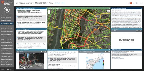
A situational awareness dashboard that shows real-time emergency alerts developed by InterCEP and used by public and private organizations including the Port Authority of NY and NJ.