It takes a village ... or an innovative university-city partnership
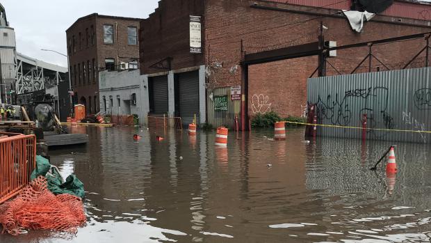
The Center for Connected Cities with Smart Transportation (C2SMART) hosts a virtual panel on FloodNet, a consortium monitoring and measuring the effects of flooding on New York neighborhoods.

Tandon researchers work with a consortium called FloodNet to develop a publicly-accessible platform that provides real-time flood information.
When NYU Tandon School of Engineering professors Andrea Silverman and Elizabeth Henaff set out to study the microbiome of city streets after flooding, seeking to discover how sewage and other contaminants were affecting New York’s flood-prone neighborhoods, they were faced with a dilemma: there was no way to predict when flooding might occur so that they would know where and when to take samples.
The group joined forces with Charlie Mydlarz, a research assistant professor at NYU Tandon's Center for Urban Science and Progress (where Henaff and Silverman are also faculty members), to design and deploy a series of sensors that would gather data and alert them to the presence of hyper-local flood events.
On May 24, Silverman, Henaff, and Mydlarz conducted a well-attended panel discussion under the auspices of C2SMART, which is based at NYU Tandon, to explain the initiative and why it is proving so effective.
Now joined by the Science and Resilience Institute at Jamaica Bay and the Advanced Science Research Center at the City University of New York (CUNY) to form a consortium they’ve named FloodNet, the Tandon researchers explained that before their sensors were deployed, existing flood data had focused only on catastrophic events like hurricanes and that smaller, local events, including tide-related nuisance floods and floods related to inundated sewer systems, had been recorded only through community reports to the Community Flood Watch program and New York City’s 311 service request portal. And while the data was publicly accessible, it was sporadically collected, and it didn’t include important information like flood depth and verifiably accurate flood location.
FloodNet’s goal is thus to create the first systematic, continuous, and accessible record of regular and catastrophic street-level flood events in the city.
It’s a goal that requires a strong team effort, they explained at the panel.
It was staff at the NYC Mayor’s Office of Resiliency (now the NYC Mayor’s Office of Climate and Environmental Justice) and the Mayor’s Office of the Chief Technology Officer, who first suggested that the universities join forces, and once those introductions were made, the members of the newly formed consortium began collaborating on sensor development and data management and merging their data streams. The result has been small, low-cost, easy-to-install, solar-powered units that work in real-time to transmit relevant data.
In addition to collaborating with one another, the teams consult on a regular basis with city agencies and community groups to refine design needs and confer on new deployment locations.
City agencies, they explain, are greatly interested in using the sensors to collect data for resiliency and transportation planning and to provide hyper-local data that could be used to activate the city’s emergency response center in a more targeted and effective way.
Because flooding affects public health and safety, mobility, infrastructure, and the economy — and because climate change is likely to only increase the frequency and severity of flooding events, the work being done by FloodNet is vital. “There are commercial flood-monitoring solutions available, but they tend to be expensive and require satellite connections,” Mydlarz, whom the team jokingly refers to as “their sensor guy” explained. “FloodNet ticks all the boxes though: our sensors are open-source and affordable and don’t rely on infrastructure or connectivity for power, since some areas are not conducive to that.”
The researchers stressed at the panel that they represent just one piece of an all-hands-on-deck effort. In addition to NYU Tandon, CUNY, and multiple city agencies and community groups, FloodNet enjoys the support of the New York State Empire State Development Corporation and the Sloan Foundation, which is allowing them to develop a real-time dashboard to integrate and disseminate data (including not just information from the sensors but community-reported flood events, rainfall data, 311 complaints, and related social media posts) to a range of stakeholders, and to install greater numbers of sensors in flood-prone neighborhoods throughout the city. Notably, the NYC Extreme Weather Task Force has included plans to scale the flood sensors and a full flood-detection and monitoring system to all of New York City in its strategic plan to combat extreme weather.
“As researchers, we’re happy to be working with government and community partners to advance the common good in this way,” they concluded.


