Flood sensor project will offer city real-time data as storms intensify
Over the next five years, the city, relying on a team of academics from NYU Tandon and the City University of New York (CUNY), plans to install 500 sensors in places across the city that see routine flooding. So far, they have installed 28, mostly in clusters in the south Bronx; Red Hook and Gowanus in Brooklyn; southeast Queens; and in Harlem.
At NYU [Tandon], Andrea Silverman [assistant professor of civil and urban engineering and a member of the Center for Urban Science and Progress (CUSP)] had set out to research contaminants in flood waters, but realized there was no good data on where it flooded. At CUNY, researchers with the university’s Science and Resilience Institute at Jamaica Bay were working with residents of Hamilton Beach, which abuts the bay, to photograph instances of local flooding.
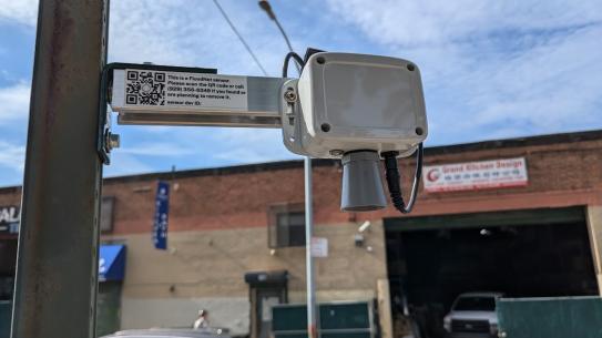
The sensor, Charlie Mydlarz [research professor at NYU Tandon and CUSP] explained, was a basic but effective piece of hardware: A lens pointed toward the ground sends out an ultrasonic beam every minute; it then measures the milliseconds it takes for the beam to return to the sensor, and calculates the distance to the ground — or to a growing pool of water.
“If there’s a flood, they're gonna pick up the depth of the flood, every minute, send it to this gateway, and it comes back to us, back to our servers,” Mydlarz said. “We plot the data, we alert any relevant city agencies to any flooding events, and we hopefully help out in these situations when the city floods.”
Already, the sensors installed in Gowanus have shown how “hyperlocal” flooding is, Silverman says. Curves showing water height picked up by the sensors during Hurricane Henri last August show some intersections experiencing two peaks of flooding, while others have a quick rise followed by a quick drainage.